Hurricane Center Upgrade…07/12/2025

NHC 7 day outlook and discussion 8:00 pm 07/12/2025

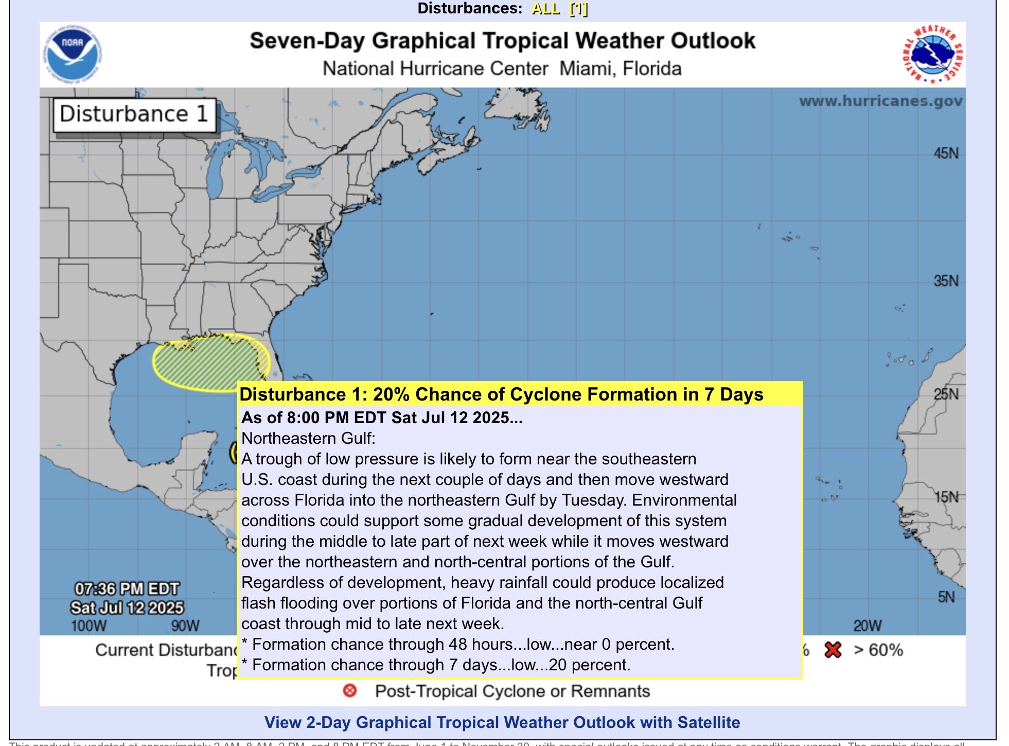
While I was having dinner with family tonight, I noticed this popped up in my feeds. It looks like there is enough support for something to get going. I think I had said something yesterday, during my last video that a “home-grown” (stalled front) tropical system could spin up.

I was then pointed to this…

Google Deep Think weather lab experimental ML model.

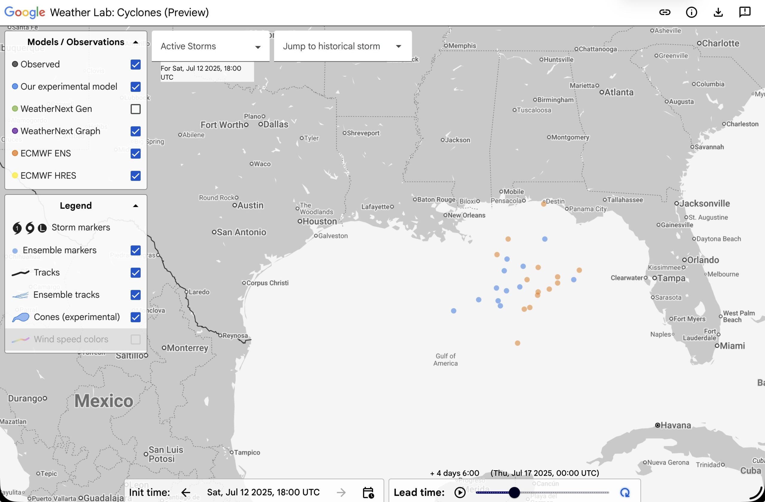
The blue is the machine learning weather model ensemble, the orange the ECMWF ensemble. This is Wednesday at 8 pm, and the center of low pressure systems from the models. So, I went over to TropicalTidbits.com to look at the model ensemble runs from the same time.

GFS Ensemble (GEFS) at 2am Wed. (Red numbers are low pressure centers. Blue high)
ECMWF Ensemble for 2am Thursday (EDT)

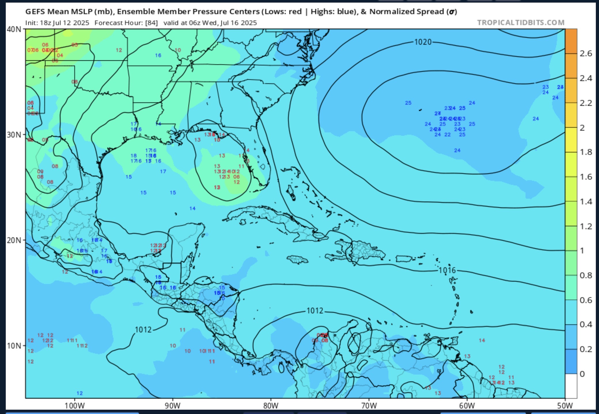
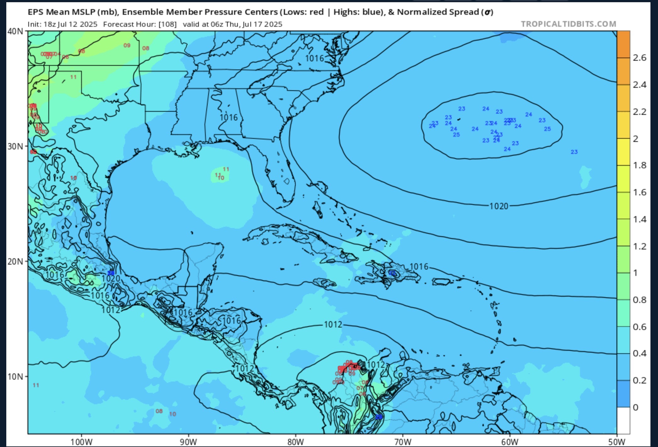
So there is a spread of time when we could see something form. And then where does it go? The models are all over the place. There is enough support that a depression will form in the Gulf, between Wednesday and Thursday, and move to the west before moving north. So far the models show weak systems. However, this is the time to prepare. Don’t get caught flat footed.

Something looks like it will form, but the strength and timing are unknown…

Coffee and a Weather Map with Jeff…07/11/2025

A quick one today, as we are moving the RV downstate to be closer to the boat we are purchasing!

Coffee and a Weather Map with Jeff…07/10/2025

Coffee and a Weather Map with Jeff…07/09/2025

Here’s the latest Coffee and a Weather Map with Jeff for 07/09/2025…

Comment below if you have a question or a weather request, or at my instagram/facebook/x/youtube pages.

Updates with Jeff…07/08/2025

Weather Updates with Jeff…Evening 07/07/2025

Coffee and a Weather Map with Jeff…07/07/2025

Still a heavy rain threat in central Texas today. Also a heavy rain threat for Mid-Atlantic States with the remnants of Chantal. Severe threat in the Nebraska (since updated to include South Dakota). Heavy rain threat in the Lower Great Lakes and New England. Northern Michigan and South Texas forecasts, and started doing a Great Loop forecast by sections. This is a work in progress.

X: https://x.com/nmirecwx
Facebook: https://facebook.com/recreational.weather
Instagram: https://instagram.com/recreational.weather

Coffee and a Weather Map with Jeff…07/06/2025

Things mentioned in this video…

  • Tropical Storm Chantal
  • Heavy rain in Texas
  • Thunderstorms in the Upper Great Lakes, the Central Plains and New England
  • The Great American Loop

Happy Fourth!…07/04/2025

Looking at the surface map this morning you will notice a theme…the main weather will be where this morning’s fronts and lows are. Not that they aren’t usually, but the marginal and slight risk areas are aligned pretty well.

SPC outlook for today

The slight risk is near the surface low near Minnesota and North Dakota, with a general (level 0 of 5 in severity) risk of thunderstorms along the warm front that stretches into Michigan. Looking at the local APX (Gaylord, MI) forecast late day 15-25% Chance for thunderstorms. Of course, the exception is the south where there is high pressure, but loads of moisture for afternoon thunderstorms to pop up.

Screenshot

WPC has a much more scaled back out look for today with chances for heavy rain in eastern North Dakota a northern Minnesota. Another MCS in Central Texas tonight (there is ongoing flooding in San Angelo as I write this). And then Florida with the tropical moisture.

NHC 7 day outlook

Last, but not least, the SE Atlantic states are now at a 60% chance for formation in the next 2 days with the remnants of the cold front where thunderstorms are beginning to form a low pressure system that will be a tropical system. I left the discussion for it on the graphic.

So there you go. Happy Fourth of July!

Looking at the Day’s Weather…06/30/2025

We are at that transition time of day, when the thunderstorm complexes are falling apart (usually), and the afternoon convection are puffy cumulus clouds on satellite, with a few showers around. Such is the MRMS radar page above. The hot spots from last night are ebbing, with the main fronts still showing some organized rain.

The map on the left is the surface map from 8am this morning with cold front pushing into the Upper Great Lakes. The showers and thunderstorms associated with it have either died, or pushed off into Canada or Lake Huron. That front trails southwest, into eastern Colorado, with what’s left from last night’s convection dying in Kansas. Otherwise, there is still a shortwave in the eastern Gulf, near Florida’s Big Bend region which is kicking off showers and thunderstorms, and the remnants of Barry in Mexico and the western Gulf.

So, the day’s heaviest rain (middle image from WPC) is expected along that cold front along the Ohio River Valley, back into Kansas. Heavy rain is also possible in New Mexico (Surprise!, not!) from the monsoonal moisture, the front, and some of the remnants of Barry.

On the image to the right (SPC day 1 outlook), there is a large area of marginal risk (level 1 of 5) along the front this morning from the Lower Great Lakes to West Texas and New Mexico. Some of this may fire off in the afternoon, but the storms are expected to be strong to severe. Otherwise, thunderstorms are expected in the eastern half of the country.

The last thing is the remnants of Barry, which we have covered, and the 20% chance for tropical development during the next 7 days. The front, that we have discussed earlier, will eventually reach Southeastern states and stretch across the Florida peninsula.

The thunderstorms are could produce a circulation. The ECMWF suggests mainly in the Atlantic off of Jacksonville this weekend, while the GEFS (ensemble GFS) mainly in the Big Bend of the eastern Gulf this weekend. Either way, there will be a lot of rain come this weekend over Florida, especially the northern part.

This is the total mean rainfall expected on the GFS ensembles through Monday morning. With over 2.5” in northern Florida and the panhandle, while heaviest rain is in the Gulf. We’ll see. (The ECMWF 06z run doesn’t go out that far).