
I am a meteorologist and a former youth leader at church…I have a lot to say on both subjects…and then some
Looking around Lower Michigan and South Texas, we got a reprieve from the heat and humidity today in Lower Michigan as the front went through. That won’t be the case in a day or two. In South Texas, it is summer, and the movement of 98L’s energy out of the region is showing a sunny and hot Sunday. For both places, the beaches would be nice. Although, Lower Michigan has some issues with rip currents today. So, let’s look at the maps…


Looking at the upper air pattern in the upper left of the gallery, the Upper Great Lakes are in NW flow, but it seems that won’t be for long as the ridge moves east and flattens a bit (Here comes the heat!). South Texas, remains hot and with the ridge over the region.


So no thunder threat today in South Texas, or Lower Michigan (Well, okay south of a line from Benton Harbor to Niles there is general thunder).


Looks like Lower Michigan gets in on the thunder action tomorrow (Monday and Tuesday) with general thunderstorms.
Looks like theGulf moisture increases again and the sea breeze produces some thunder chances Monday. Tuesday has the chance of thunder across the whole state.


Looks like most of Texas misses out on the heavy rain and the chances are less than 5%. However, Lower Michigan has chances of 5-14% for excessive heavy rain leading to flash flooding Monday and Tuesday with the next system.


In the tropics, Erin (currently, a category 3 hurricane) continues to follow (more or less) the path that the models have been saying. The color overlaid with the path is the chance of tropical storm force winds impacting area. The northern part of the island of Hispaniola is only in a 5% chance, but the Turks and Caicos islands are 20-50% chance and have a Tropical Storm Warning, with a few of the southern Bahama islands with a Tropical Storm Watch. The Outer Banks in North Carolina have a 5% chance for Tropical Storm Winds, as Erin moves NE, and Bermuda, on the other side of the Hurricane has a 20% chance (at this time) of Tropical Storm Winds. The main impact, since the storm is currently expected to remain offshore will be High Rip Current Risks and beach flooding.
Okay, so let’s look at local Beach forecasts for Lower Michigan and South Texas…
For lower Michigan…
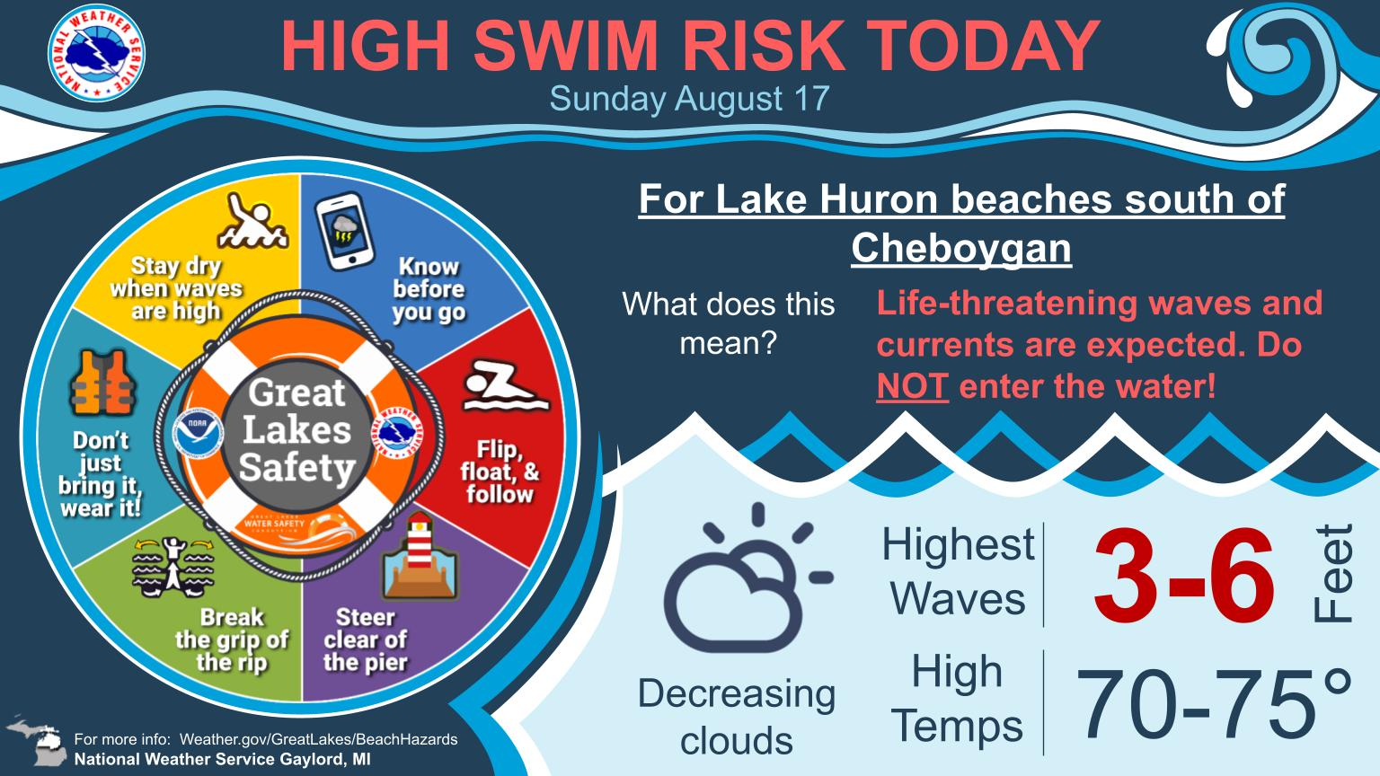


The wind is out of the NNE so and will get going, during the afternoon. So then Lake Huron Beaches are at a high risk, while most of the Lake Michigan beaches are moderate to high. Temperatures are cooler than yesterday, with temperatures in NE Lower around 70° and the SW Lower will be in the mid 80s.


Temperature today will be from the upper 80s at the Beaches to around 100º inland in the Coastal Plains and the Victoria Crossroads. For the Brush Country and the Rio Grande Plains, 100-105º. If you are used to the heat, and hydrate, it should be a good day in the Brush Country. However, if it were me, my wife and I would head to the beaches. Especially, since there is a low rip risk and the 10 MPH onshore wind would keep us cool.
Have a great day!