
I am a meteorologist and a former youth leader at church…I have a lot to say on both subjects…and then some
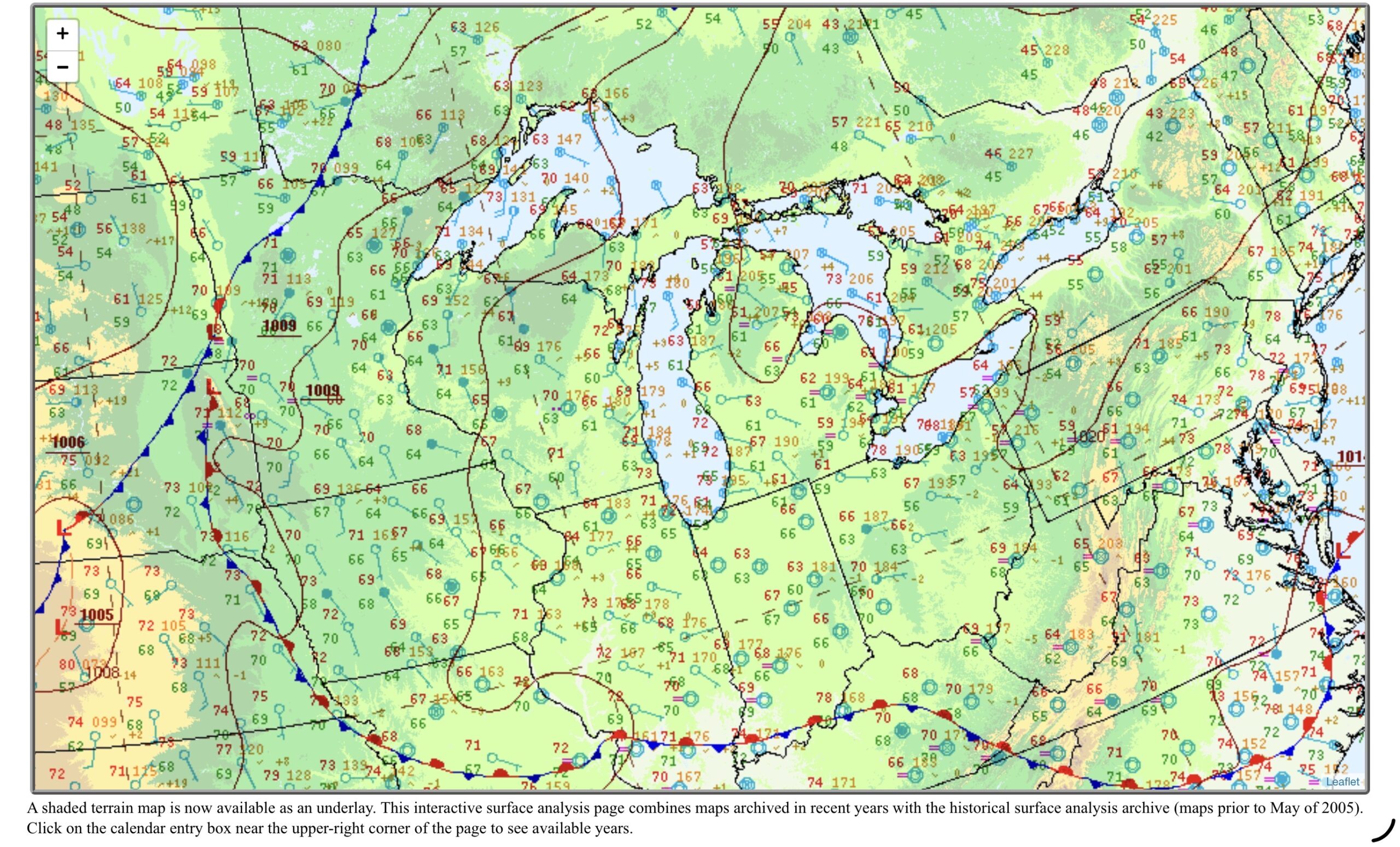
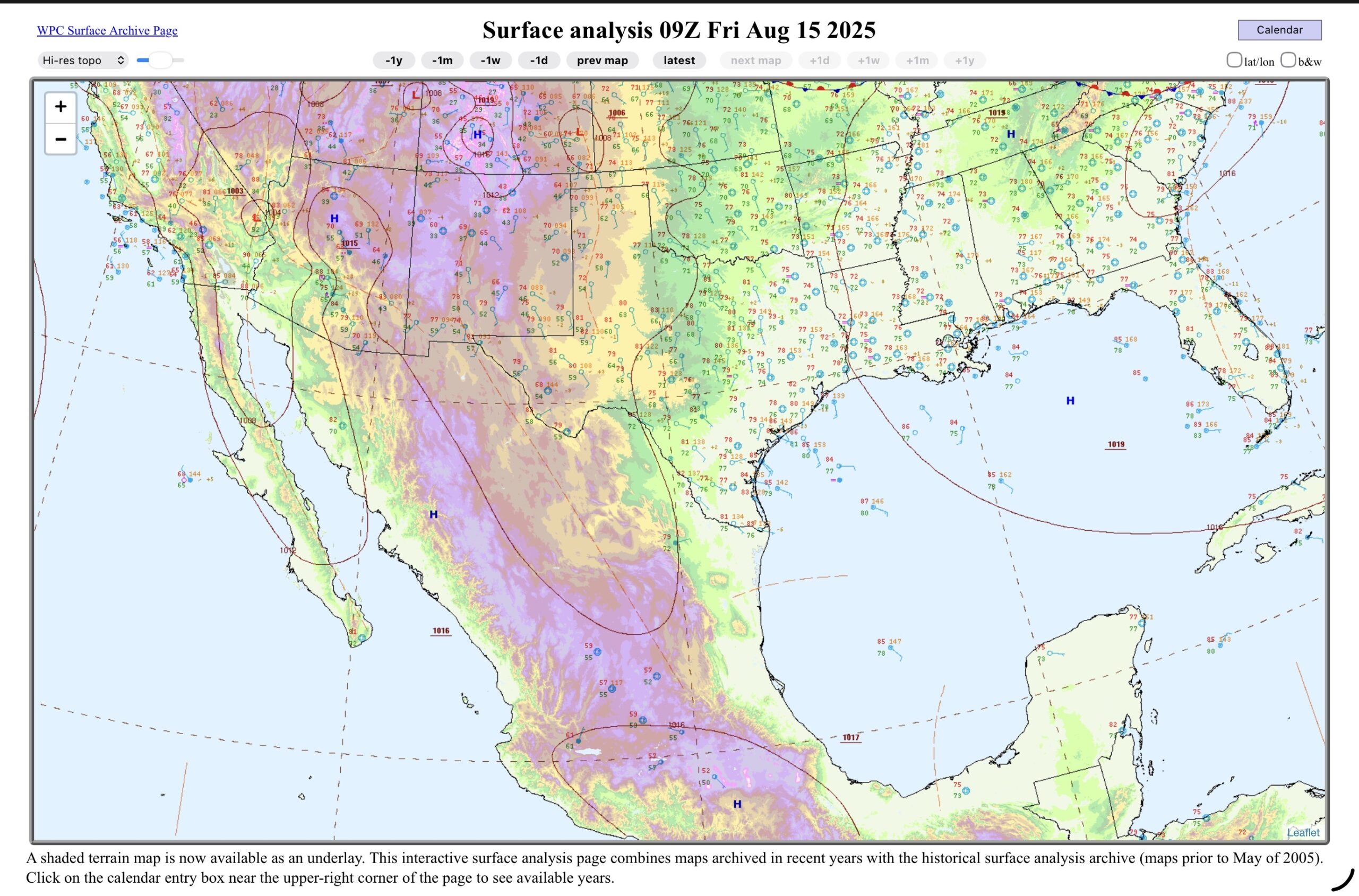
This morning I was doing a hand analysis for Lower Michigan and one for South Texas. After doing the Michigan map, I decided to turn on the screen capture, and show the analysis as it happened, for South Texas. This is where the title to the videos come from for “Coffee and a Weather Map with Jeff” comes from. I used to do them live on YouTube, and recorded it and uploaded it to my personal Facebook profile. That was 4 to 5 years ago, while I was messing around learning about how to do live YouTube and Facebook, and how it could help with spreading the word for the NWS offices I’ve worked for.
Now here I am, retired, and still loving the weather. I’m contemplating, doing the Mac Mini live again. The iPad hardware-wise may be able to handle multiple screens and live, but the apps out, and Apple’s iPadOS (18 or 26) won’t let it. In the mean time, I can screen record it. Here’s this morning’s screen recording and the final products for Michigan and South Texas…
High pressure leads to pleasant weather in Lower Michigan for the weekend. South Texas starts out dry, but rain begins to move into the region by Sunday/Monday.
0:00 – Intro
0:47 – Upper Air
2:18 – Radar
3:56 – Surface map
5:53 – Tropics
9:00 – SPC/WPC
14:45 – Lower Michigan Forecast
18:59 – South Texas Forecast
24:50 – Outro
Websites used: Weather.gov (WPC/SPC/Local offices),
https://Tropicaltidbits.com,
https://weather.cod.edu (College of DuPage),
https://ecmwf.int (European Centre for Medium range Weather Forecast)
https://beta.pivotalweather.com
Apps used: RadarScope
EverythingWeather
Web Links: https://ministry-weather.com
Facebook: recreational.weather
Instagram: recreational.weather
X: (South Texas and Lower Michigan Recreational Weather) @nmirecwx
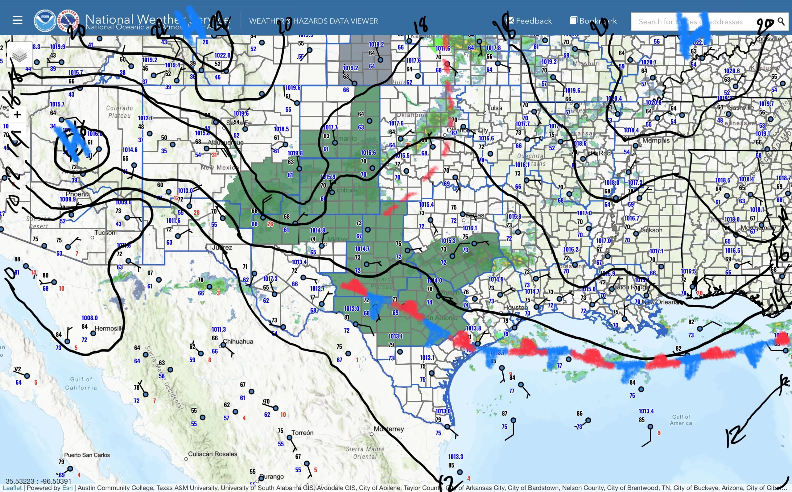
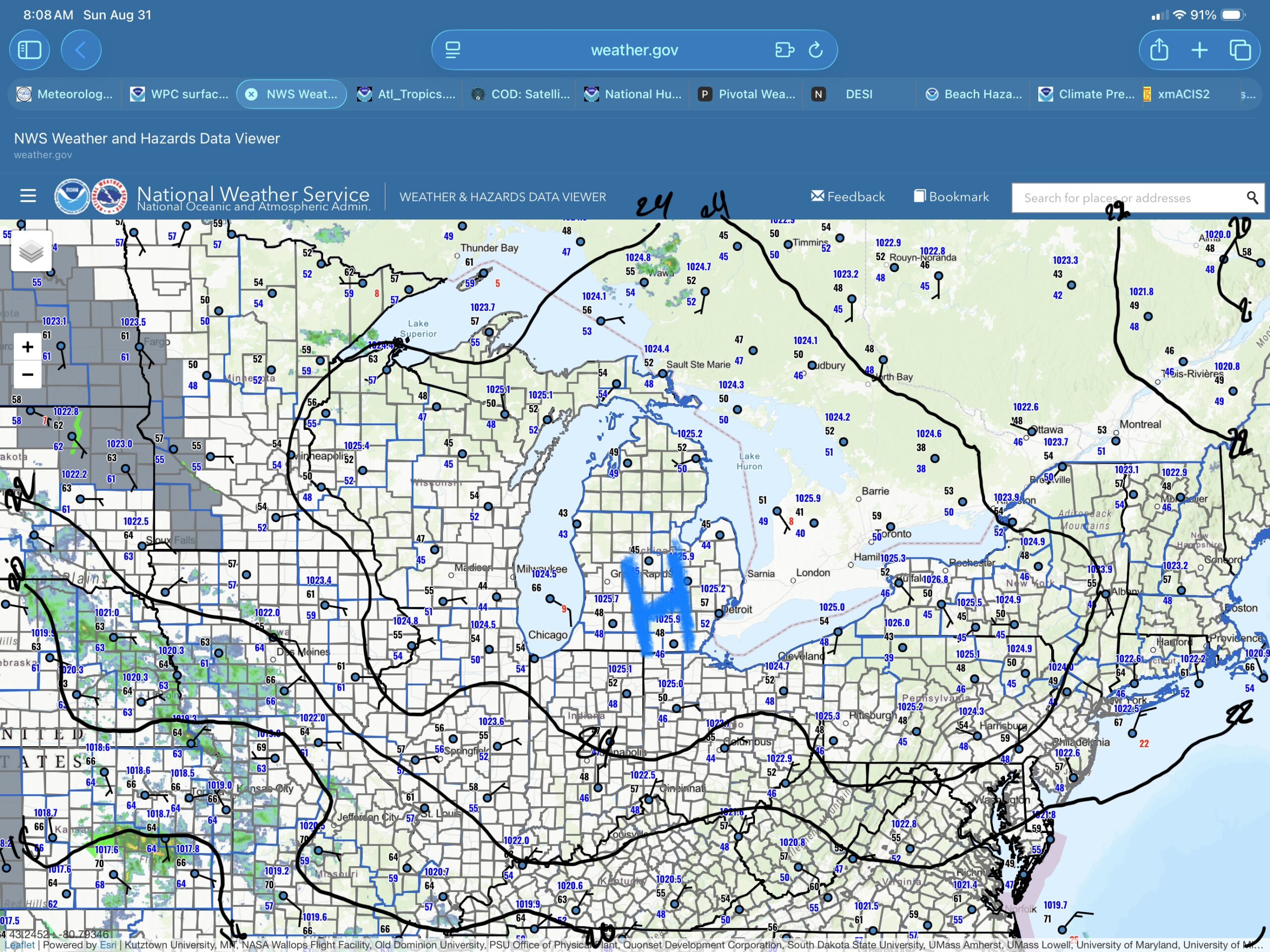
Things are a little slow starting this morning, but quiet so far. The weather is quiet as well. Over South Texas and Lower Michigan, rain is still possible in both places (there’s a little more to it than just that saying), and it is definitely cooler in Lower Michigan. So let’s get into it…
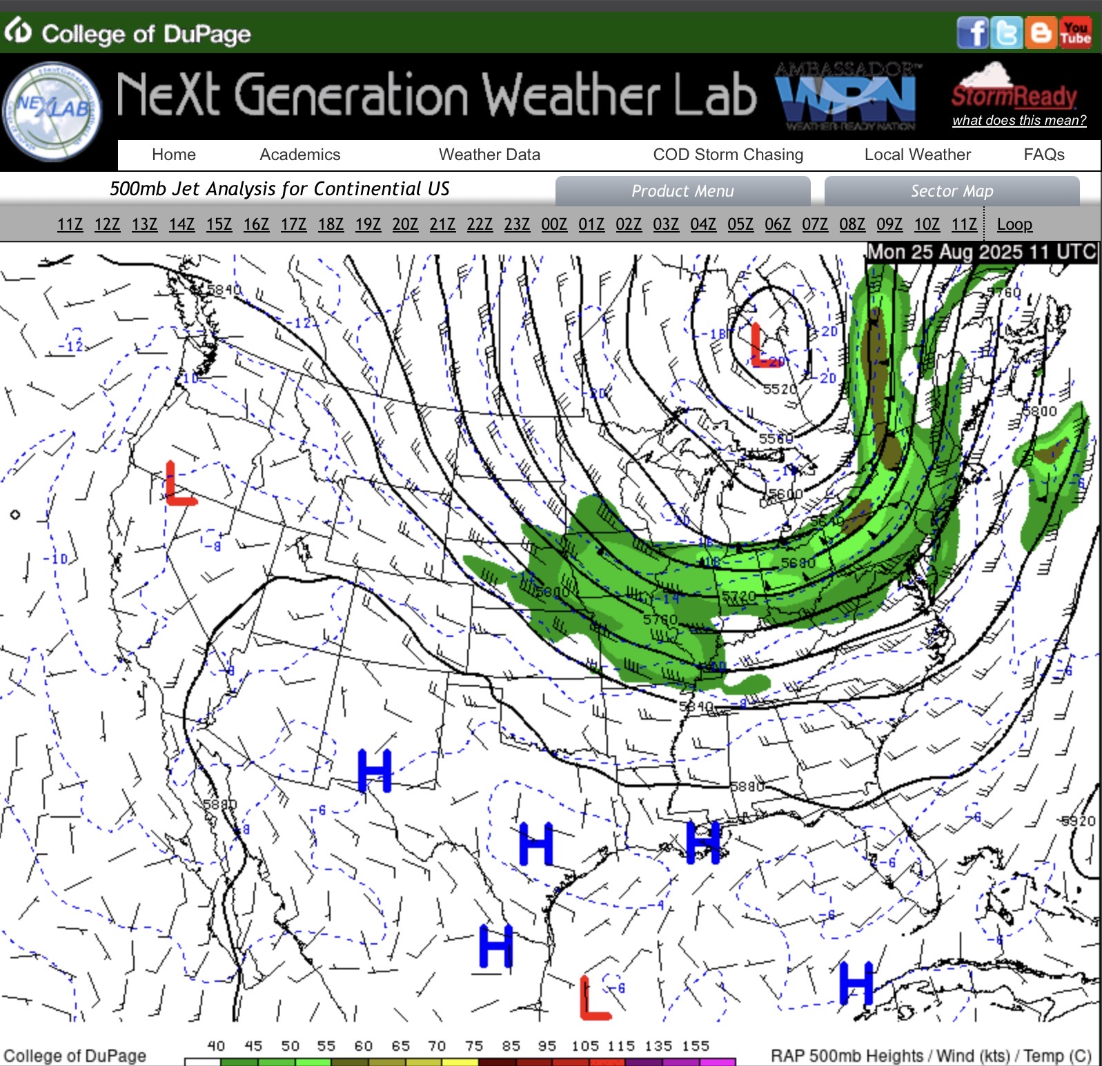
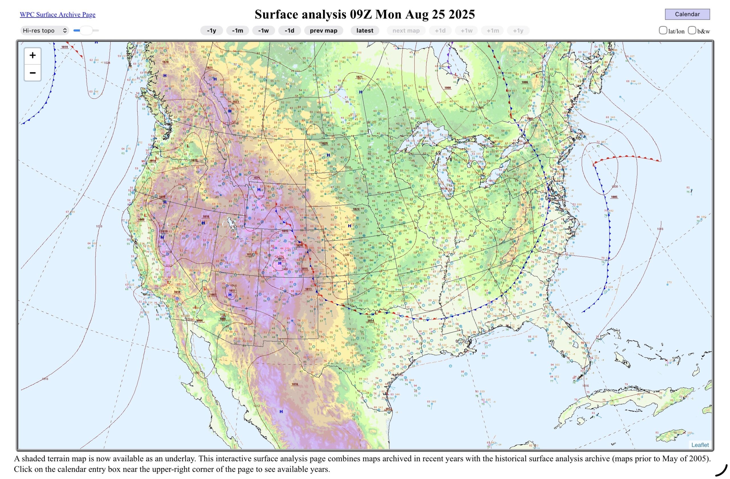
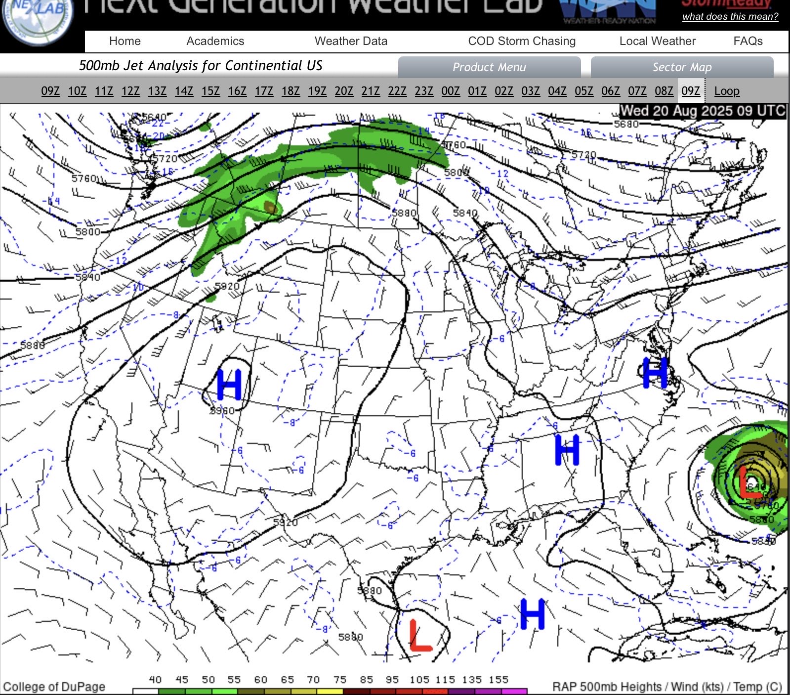
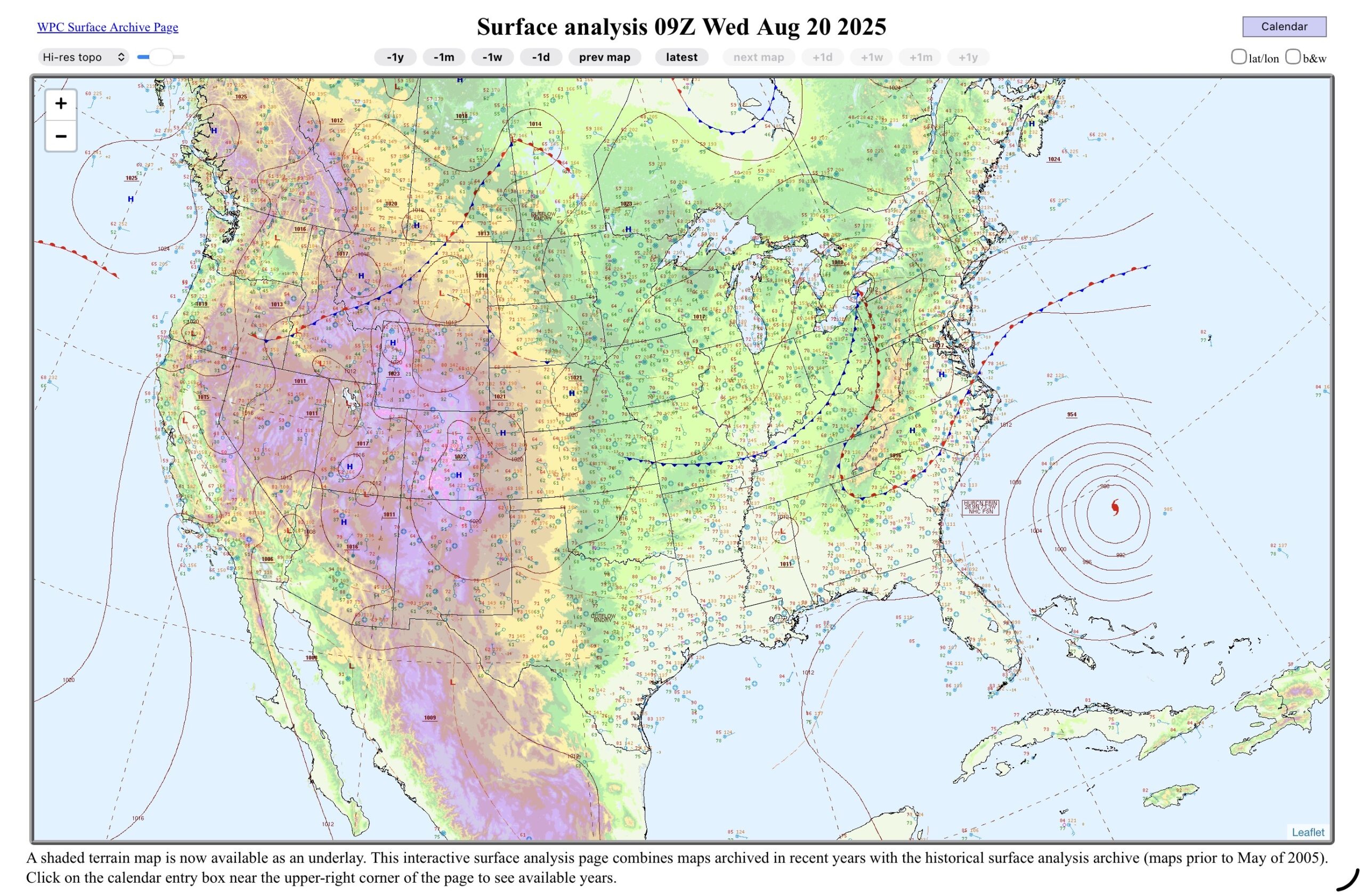
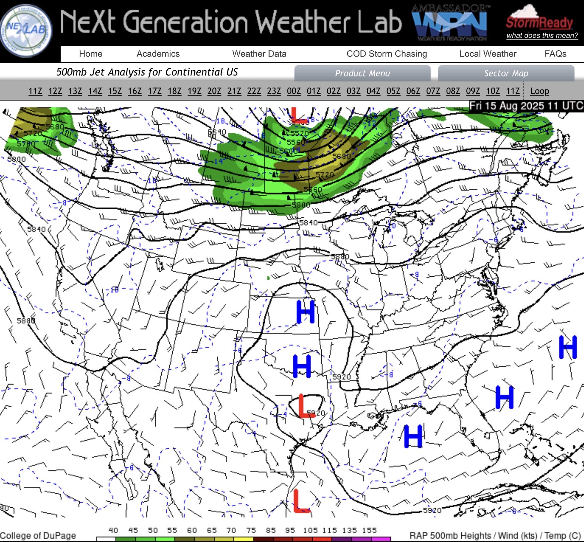
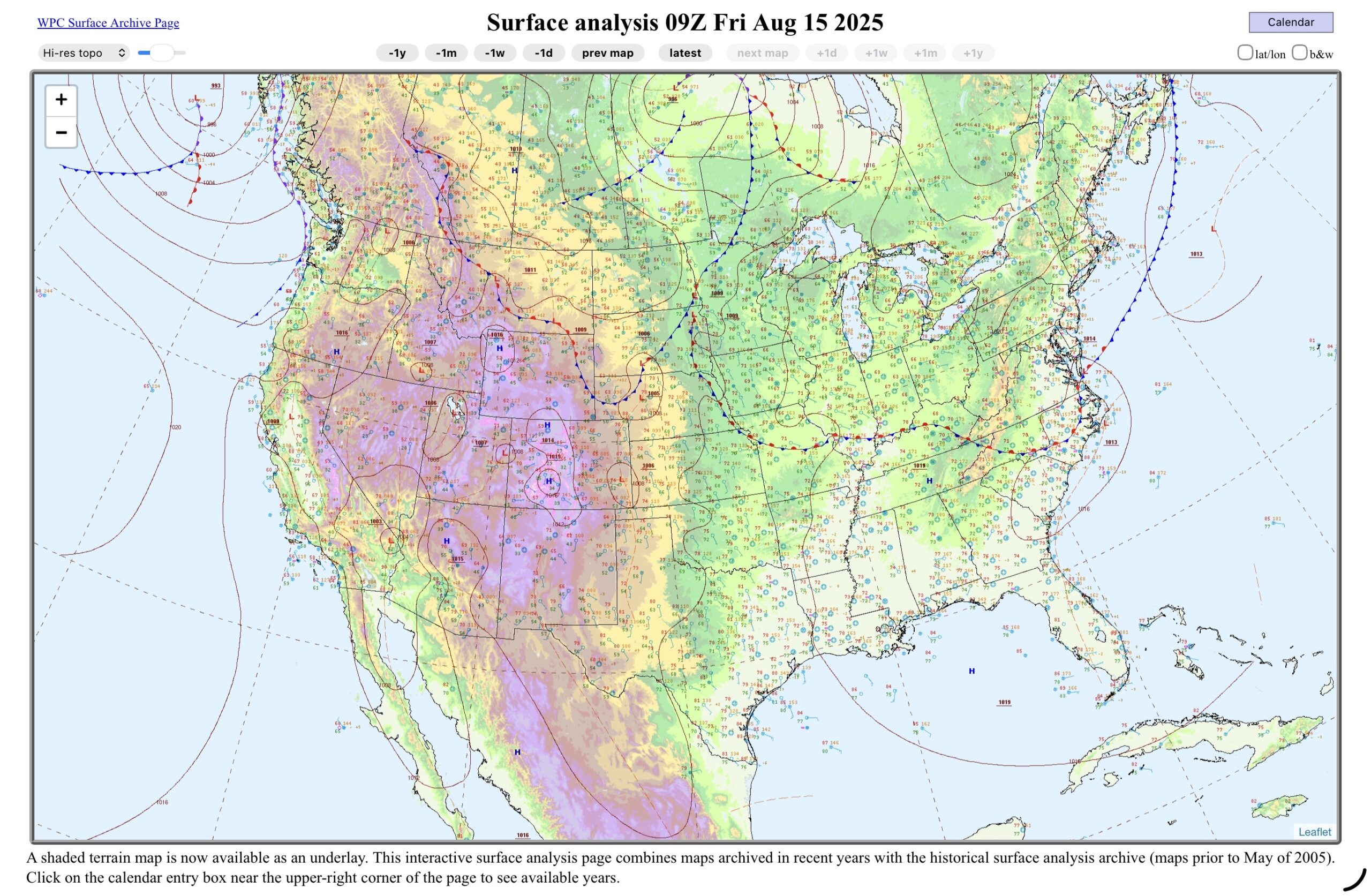
Over Lower Michigan, the upper level low to the north is still slowly moving east, but the main jet streak, is now south of the region. This puts us in the cool, unstable air, but no extra uplift from the higher winds. South Texas remains under the upper level high. On the surface map, the cold front is through the Great Lakes and is cutting through the northeastern states, and then down the east coast to the southern states, then across to North Texas, where it is a stationary front, and back up the Rockies. The stationary front, and monsoonal moisture will be a key player over the next few days. South Texas at this point looks like it back in summer mode, with onshore winds.
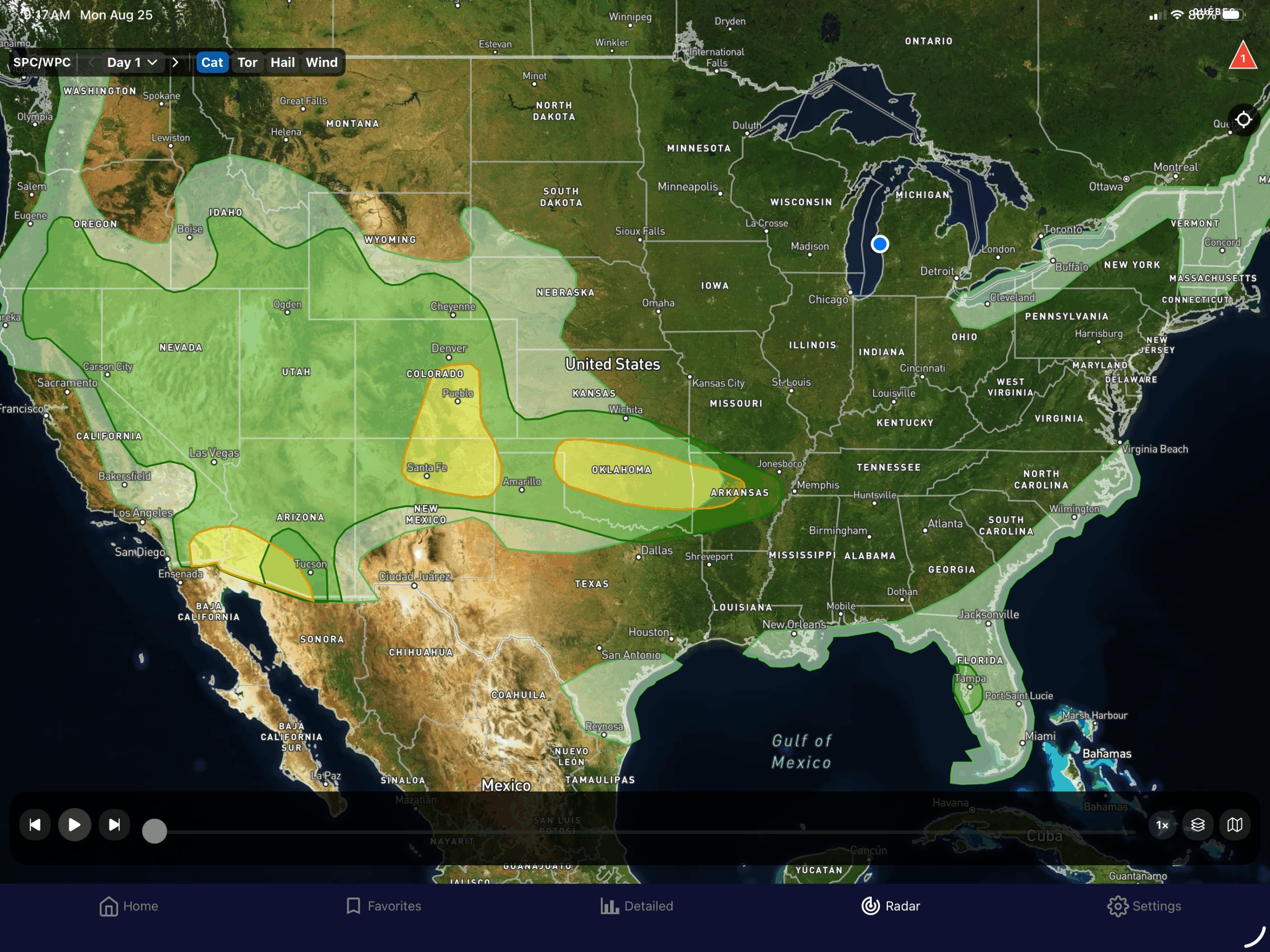
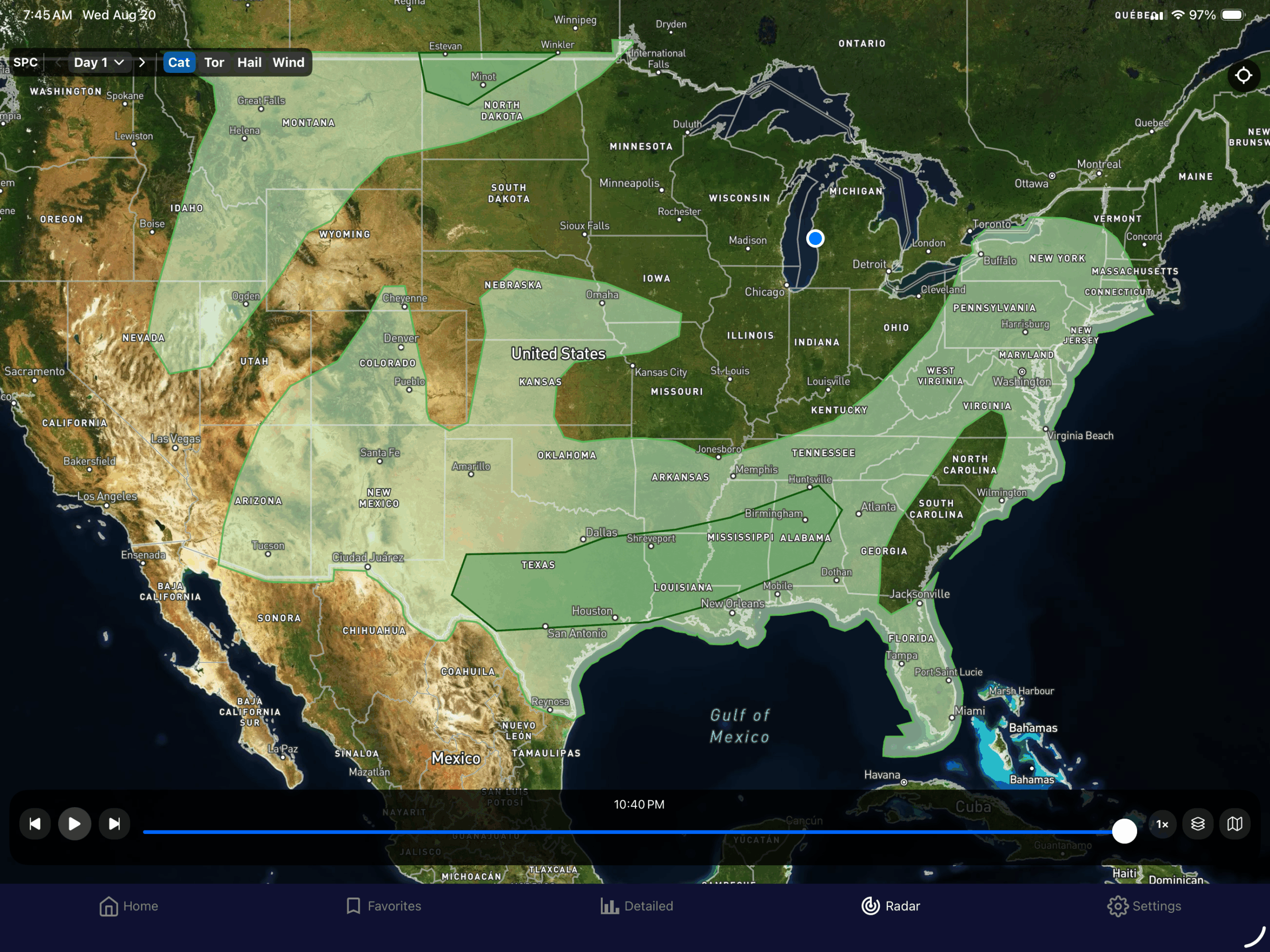
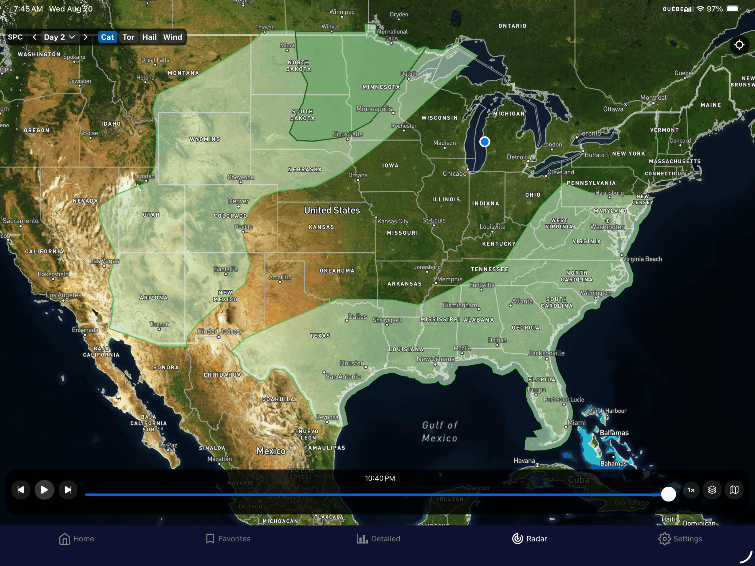
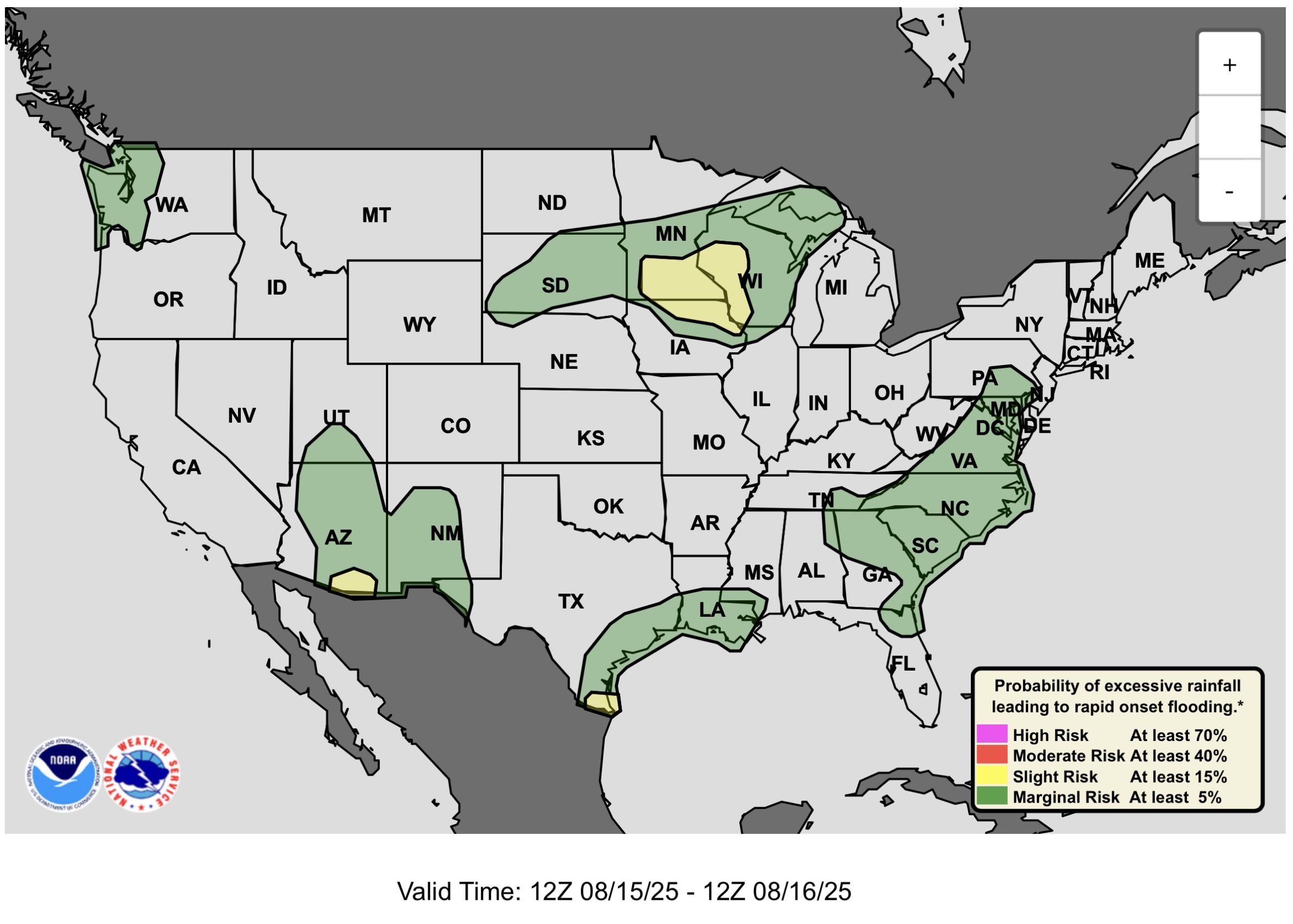
You can kind of see the outline of the front on the SPC/WPC outlooks maps this morning. The front in the Northeast kicks off showers and thunderstorms, as well as in the southeast US and along the Gulf Coast. The stationary front is the main player, along the Rockies, and the upper level ridge over most of the Desert Southwest. The slight risks are along the front in the Southern Plains, and in the Desert Southwest where the monsoonal moisture is producing a flash flood threat.
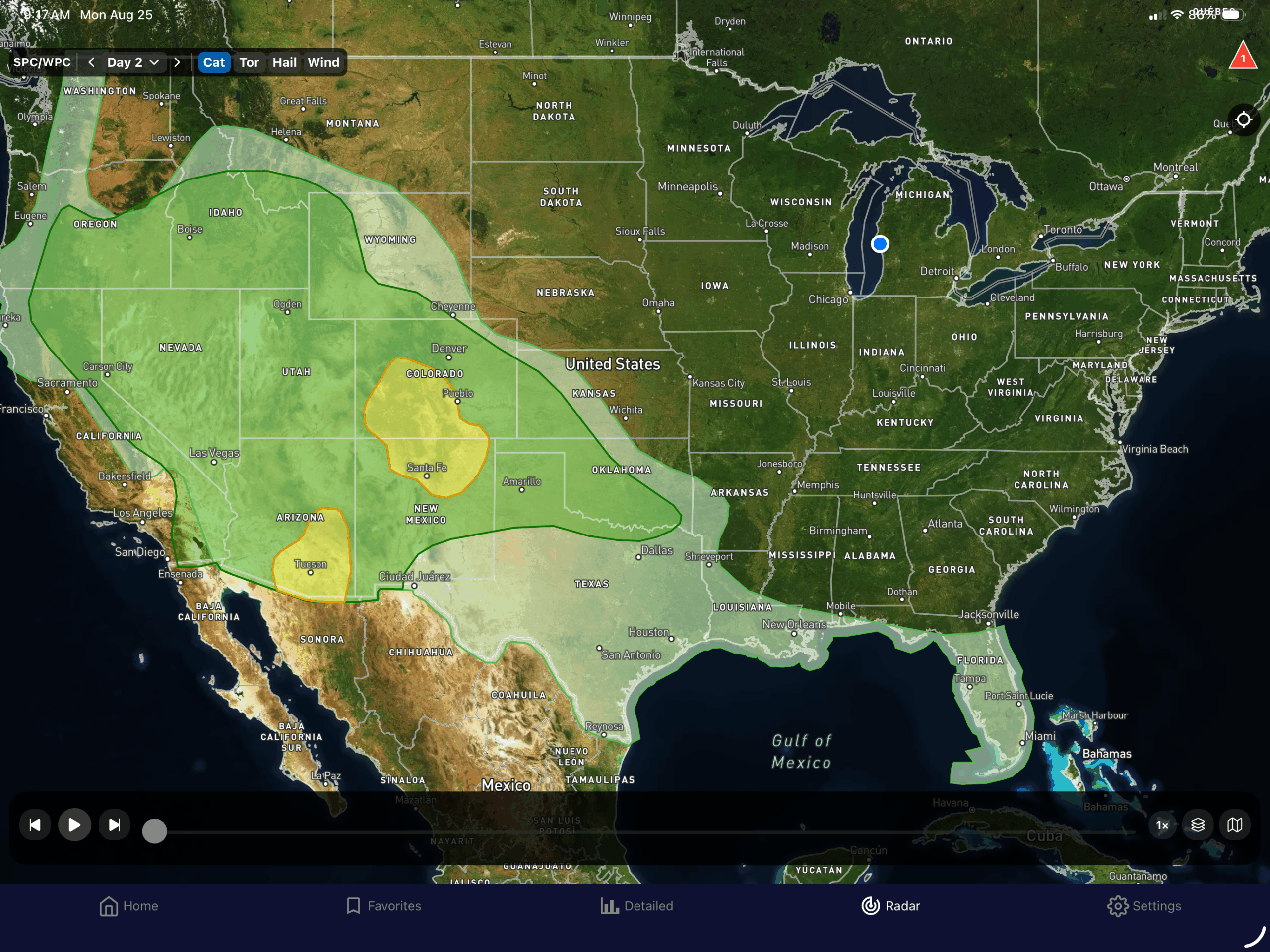
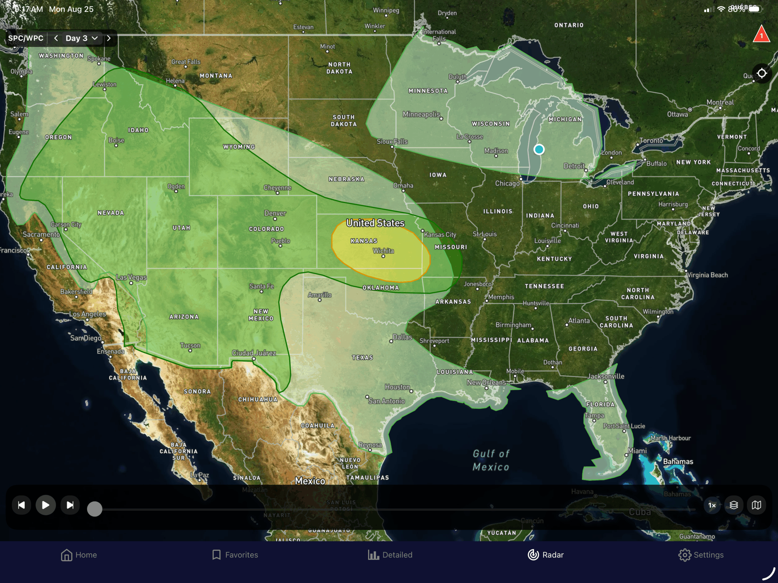
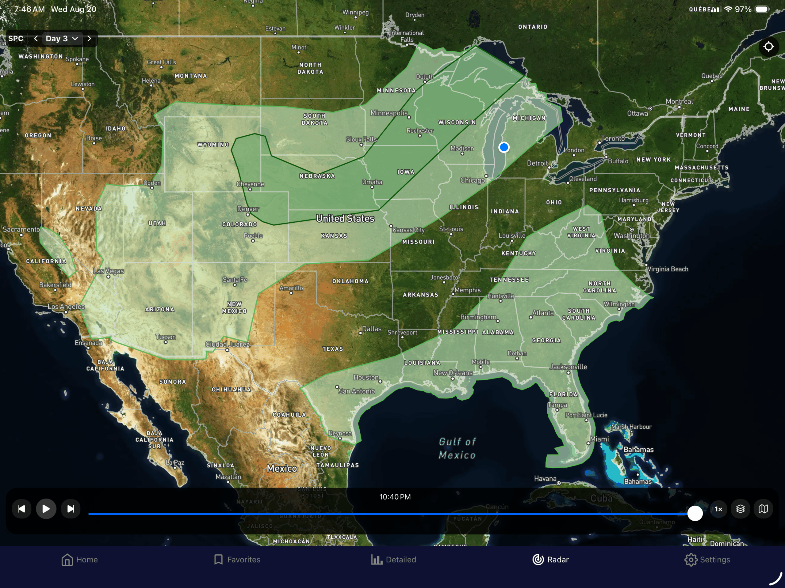
Tuesday looks similar, but the northeast rain is offshore. Wednesday looks similar as well, but there is another cold front coming down out of Canada, and into the Upper Great Lakes.
In the Tropics, TS Fernand is no threat to land, and the wave headed for the Caribbean is now at 0% chance of development.
So let’s look at the local forecasts…
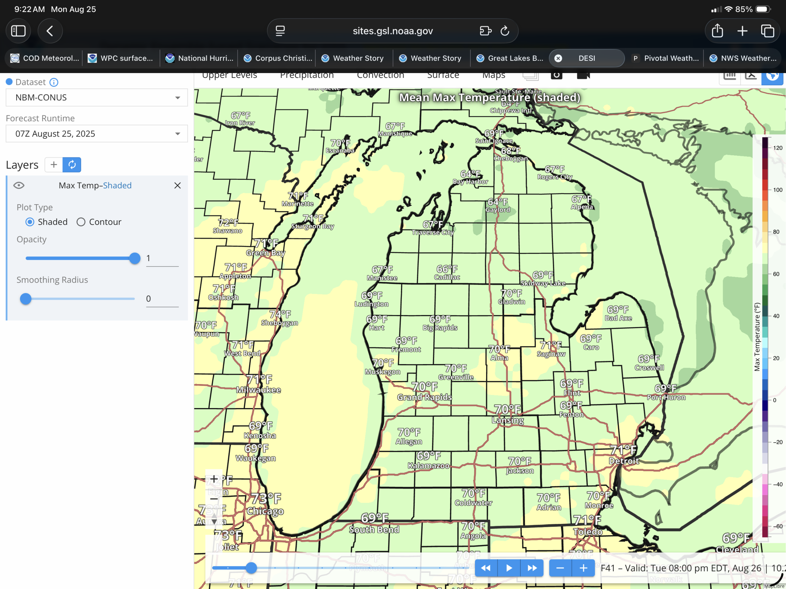
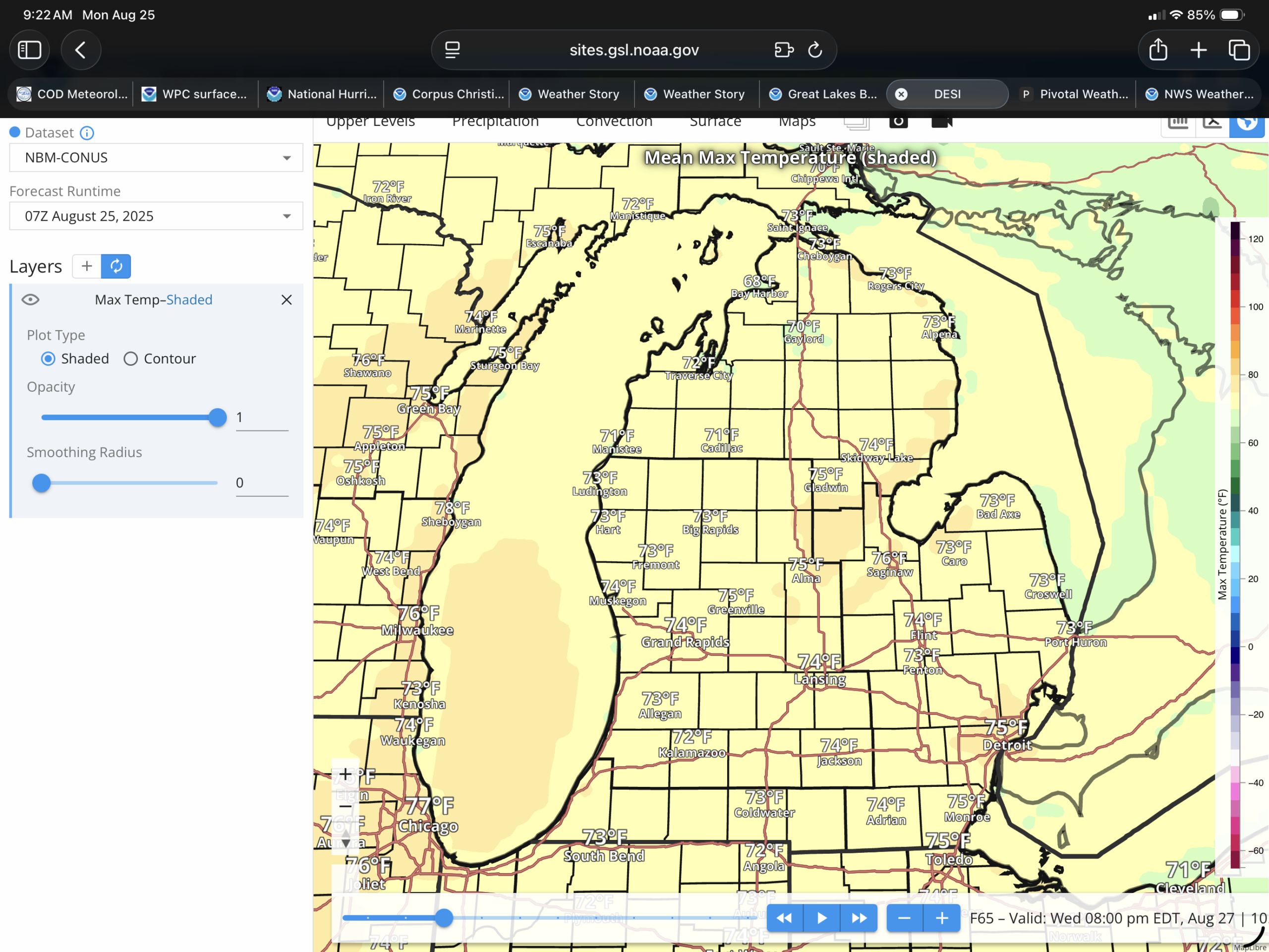
Lower Michigan will gradually warm from the 60s to the lower to mid 70s by Wednesday. Showers should be on the way down, with isolated to scattered showers expected today. Dry Tuesday, as the high moves over us, and then showers and thunderstorms are expected Wednesday with the high chances north of US-10, and the medium chances south.
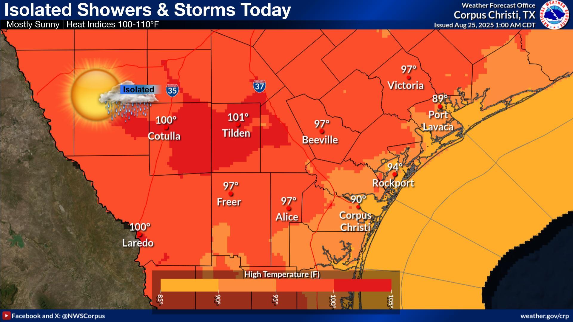
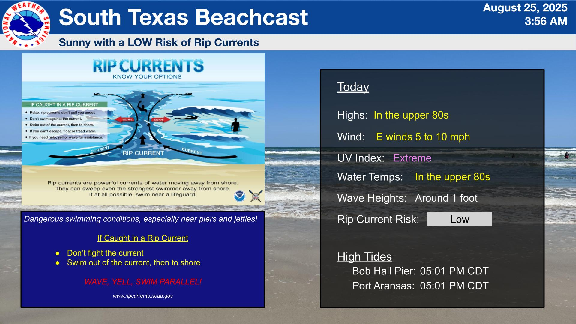
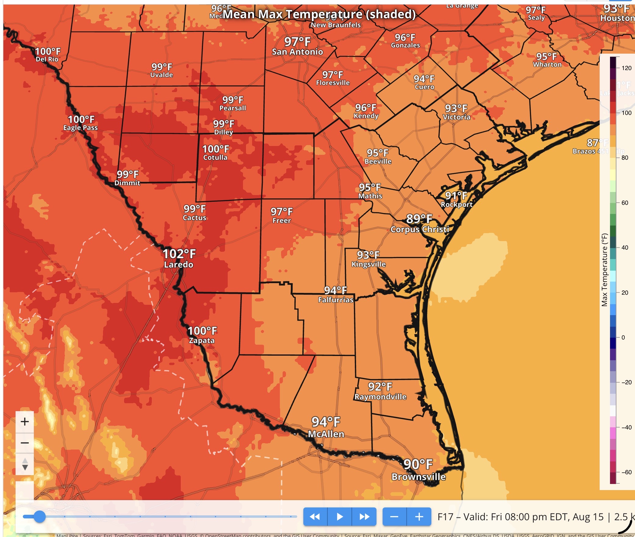
As I said earlier, South Texas is in summer mode, with temperatures back around 100ºF in the Brush Country, and the beaches in the upper 80s. Isolated showers and thunderstorms, most likely will move in with the sea breeze by the afternoon. There is a low risk of rip currents at the beach. It looks like there will be some thunderstorm chances coming up as well this week.
Colder air that moves through Lower Michigan will cool temperatures into the 60s Sunday and Monday (upper 50s?). South Texas has chances of rain through the week.
0:00 – Intro
0:23 – Analysis
4:29 – Tropical
6:43 – Radar
7:22 – SPC/WPC Outlooks
11:42 – South Texas Forecast
12:49 – Lower Michigan Forecast
15:49 – Outro
Websites used: Weather.gov (WPC/SPC/Local offices),
https://Tropicaltidbits.com,
https://weather.cod.edu (College of DuPage),
https://ecmwf.int (European Centre for Medium range Weather Forecast)
Apps used: RadarScope
EverythingWeather
Web Links: https://ministry-weather.com
Facebook: recreational.weather
Instagram: recreational.weather
X: (South Texas and Lower Michigan Recreational Weather) @nmirecwx
Had to get a few projects done on the RV yesterday, and we go our hoses changed out, on the boat. Things are coming together, although a little slower than we would like.
In the weather, of course the big story is Hurricane Erin, which is a category 2 storm.
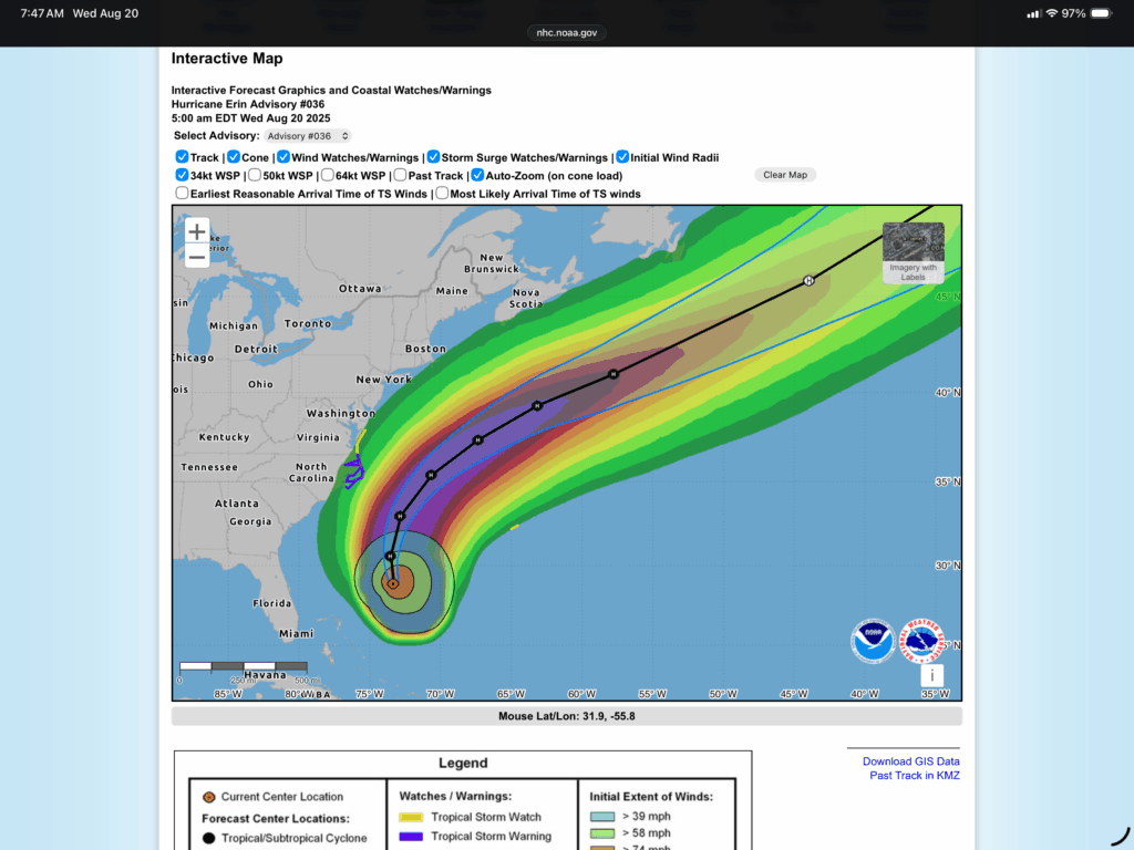
Maximum sustained winds are near 100 mph (155 km/h) with higher gusts. Some strengthening is possible during the next day or so. Weakening is likely to begin by Friday, but Erin is forecast to remain a hurricane into the weekend.
Erin is a large hurricane. Hurricane-force winds extend outward up to 90 miles (150 km) from the center and tropical-storm-force winds extend outward up to 265 miles (425 km).
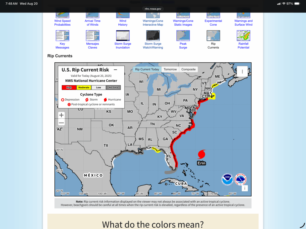
The main story with Erin, since the storm won’t make any landfalls, is the large wind field, which is producing a high rip current risk along most of the Atlantic seaboard. The only people that will be happy about this is surfers. Stay safe…
With that out of the way, let’s look the rest of the forecast…
I’ll mention that when I saw the 6-10 day outlook with below normal temperatures and then the current upper air pattern, all I could think of was the ridge/trough jet stream pattern which is starting to show. Not sure that it will remain like this, but we are getting close to September and the color change starts in Michigan soon. Anyway, the trough over the Upper Great Lakes will keeps us on the cool pattern for the next few days, and probably cloudy. We are getting into the “unstable” season for the Great Lakes, where the water temperatures will be warmer than the air temperatures, which can complicate a forecast(like cloud cover).
For South Texas, the main ridge is now to the west, and other is a broad upper low over the region, which looks to drift over the region through the next week.
On the surface chart the cold front and low is just starting to move out of the Lower Great Lakes, although it probably won’t move very fast as Erin stops thing up, until it gets into the jet stream and begins to move east. There is a front in the Canadian Prairies with a front that trails it. That will be the next weather maker in the days to come.
The Upper Great Lakes will be thunderstorm free, and probably begin to clear later today, or at least tomorrow (Thursday). Then that prairie low will move across the northern tier of states, and move into the Upper Great Lakes by Friday. So outdoor activity will be pretty good over the next couple of days (in Michigan).
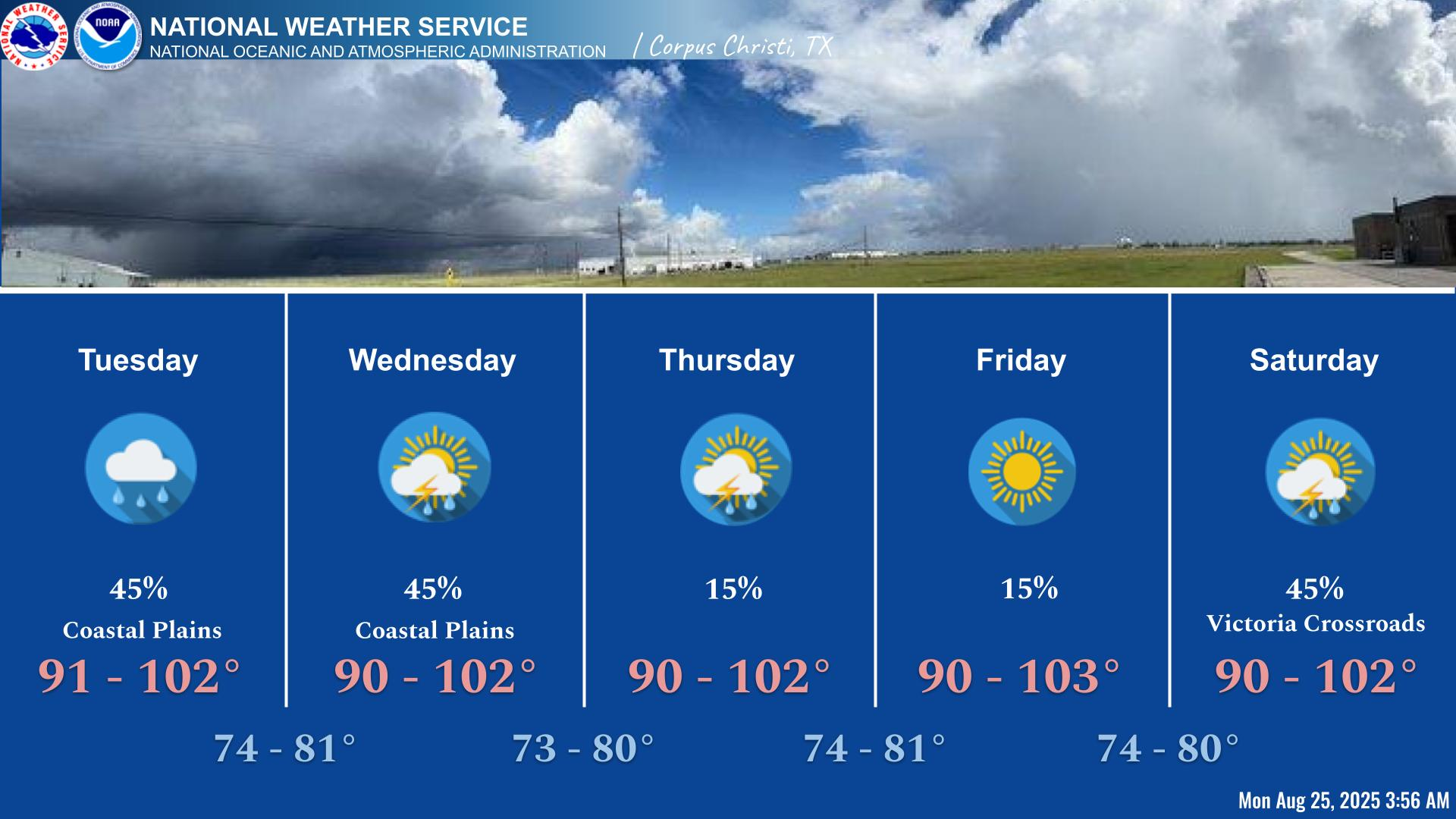
That upper level low will continue to bring a low to medium chance of rain to South Texas over he next few days. In fact, the Corpus Christi office had this graphic showing the amount of rain over the next week that is possible.
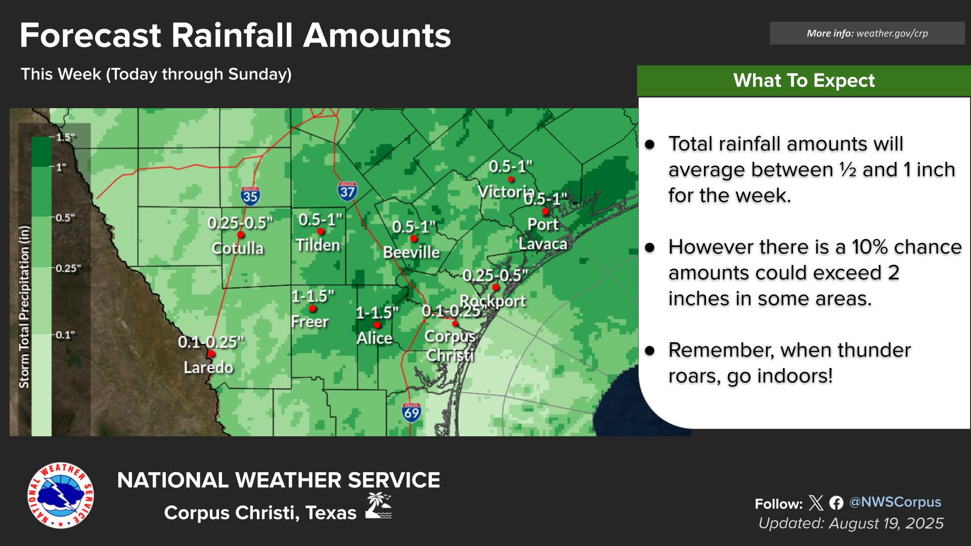
Today through Friday look like the risk of excessive rain is low the next few days in Michigan, and it is marginal on Thursday for South Texas.
So here are the local forecast for the recreational interests, primarily the beaches…
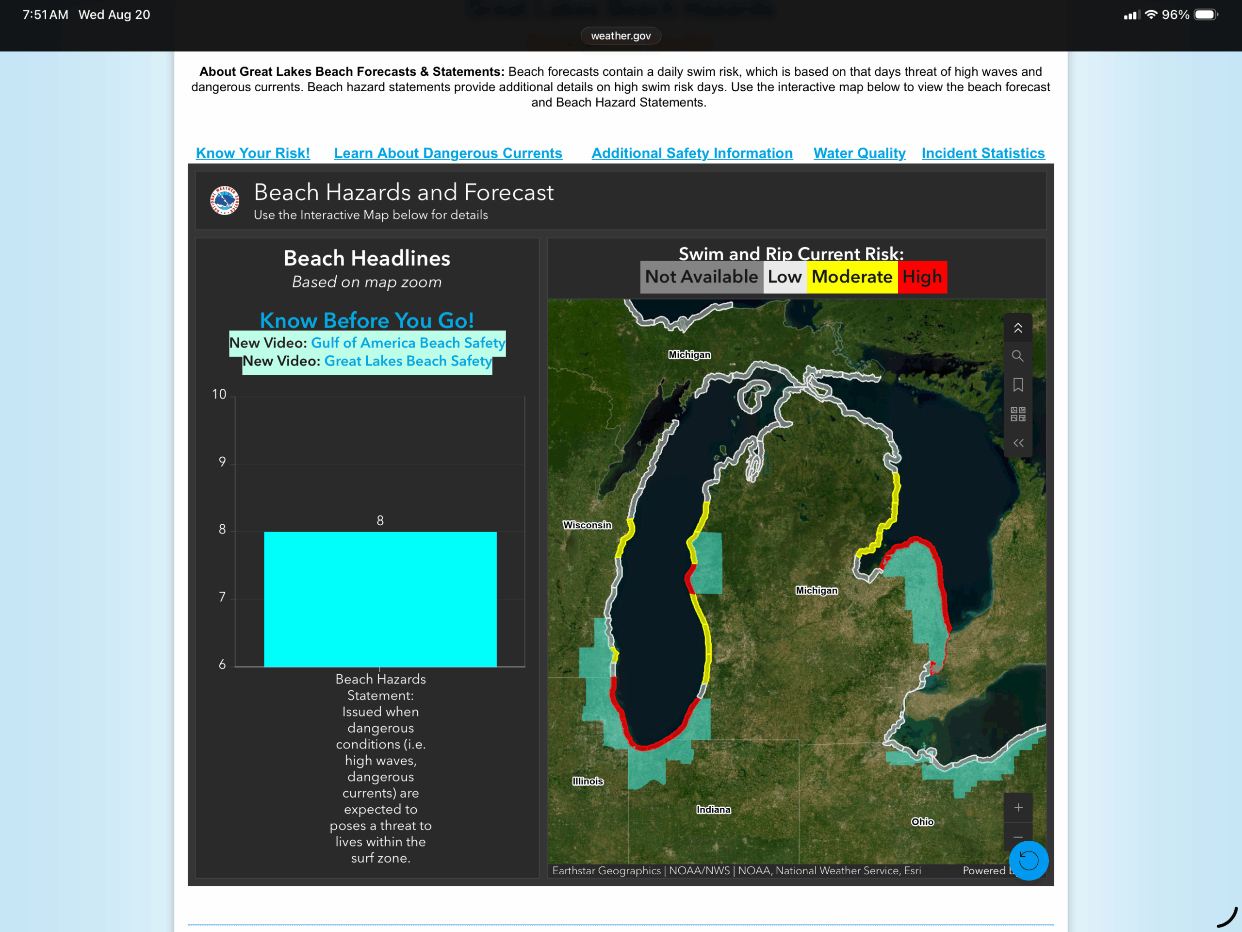
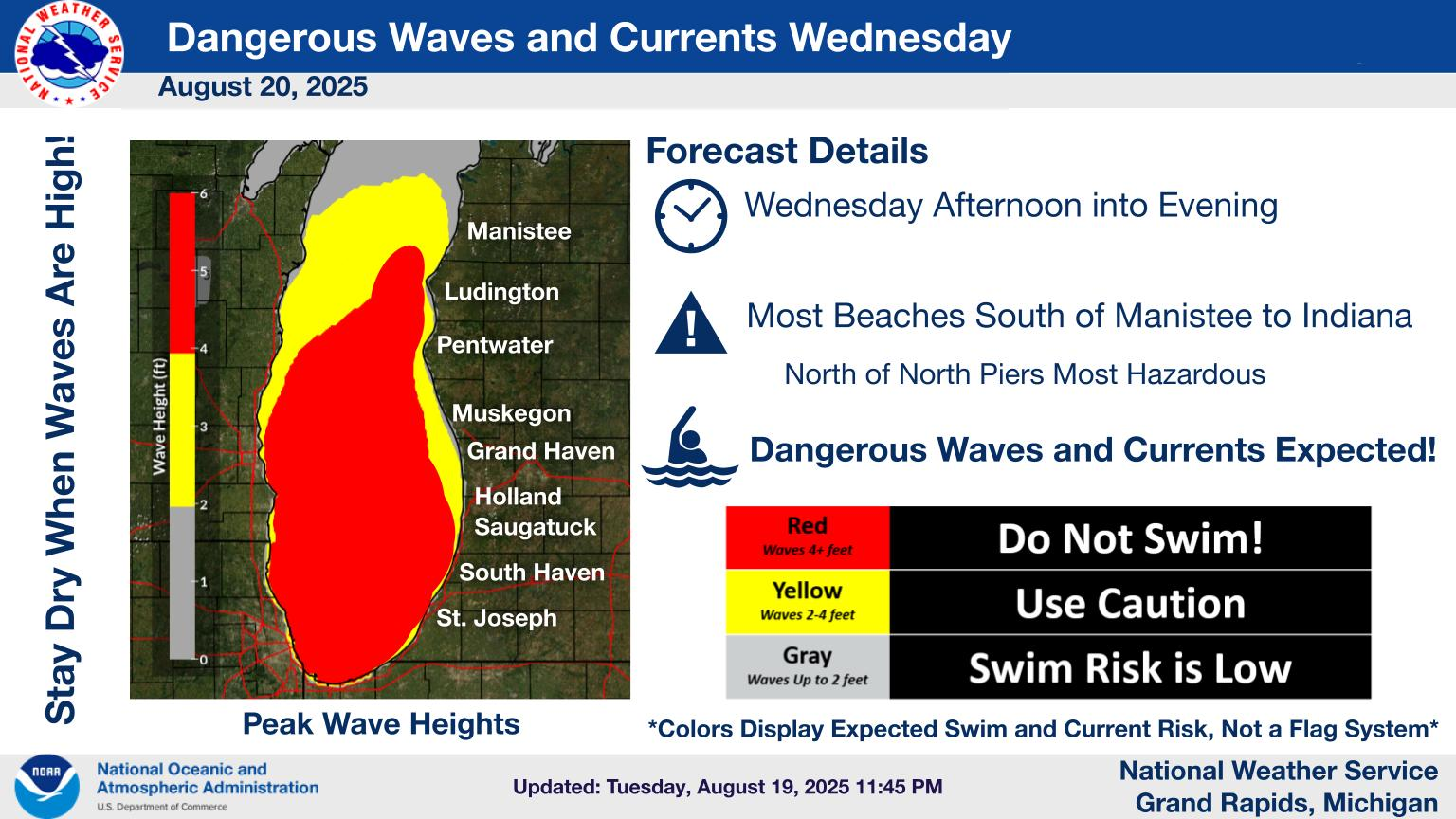
Lower Michigan has high rip risks on the north facing beaches on Lakes Michigan and Huron, primarily on the southern part of each lake. The northern parts look pretty good, but the temperature is cool.
It will continue to be hot in South Texas, so go to the beach, but beware of thunderstorms. Don’t get caught outside with a nearby storm.
So let’s look at the 6-10 day outlook…
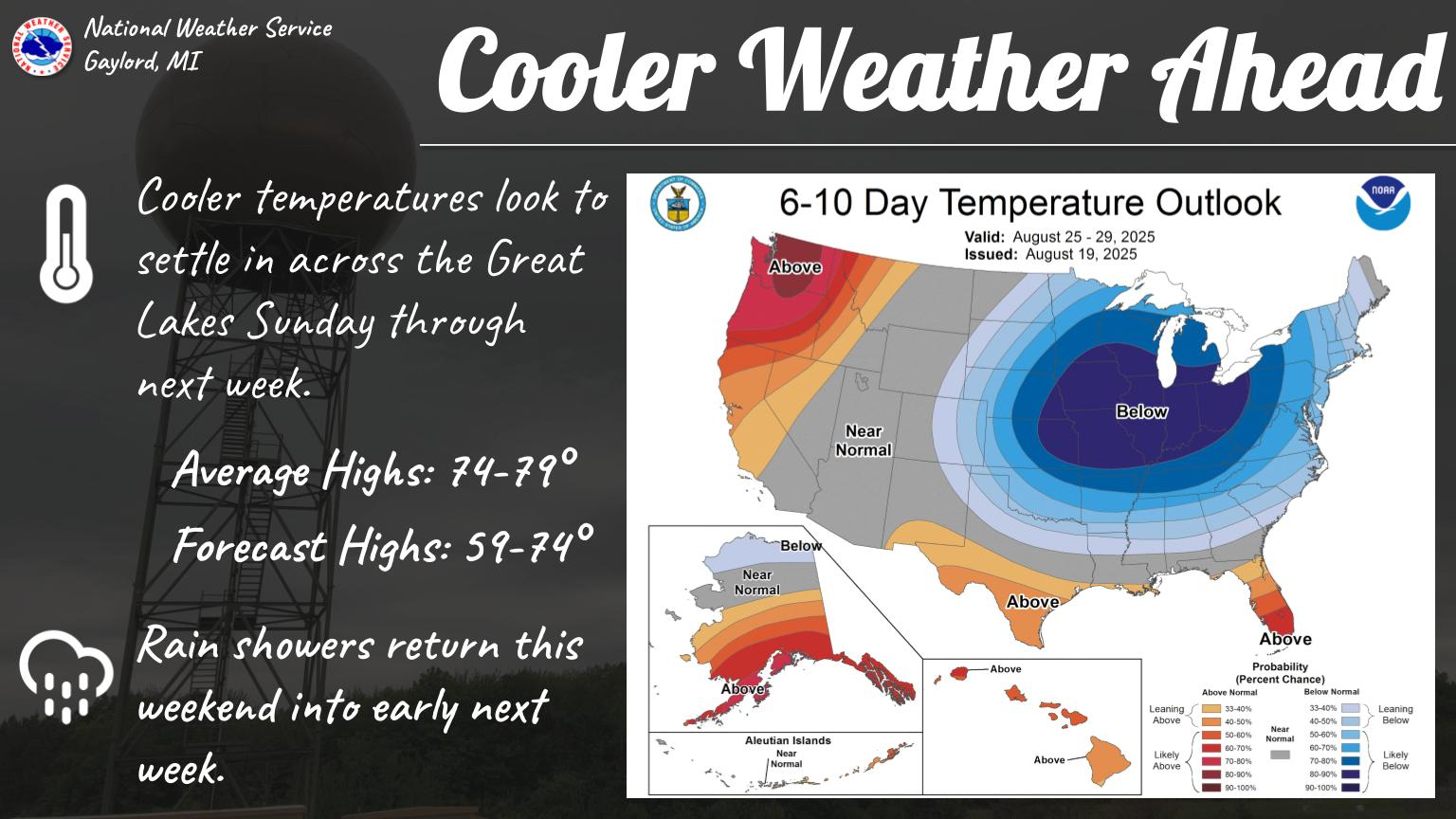
This one came from the Gaylord, Michigan office. So, they are advertising the cool down for the the 24-29 of August (no, that’s not a typo, the Climate Prediction Center (CPC) has been showing this cool down since the previous day, with it centered on the Upper Great Lakes.) which will move south and out of the region. Sorry South Texas, it’s unlikely to reach y’all, and it looks like, during that time, that you will still remain above normal.
That’s about it for now.
This morning, my website died for a bit, and we had to go to Gaylord today. So I put the post on social media. So as Erin heats back up, I thought I would put some recreational impacts over the next few days for the Atlantic Coast.
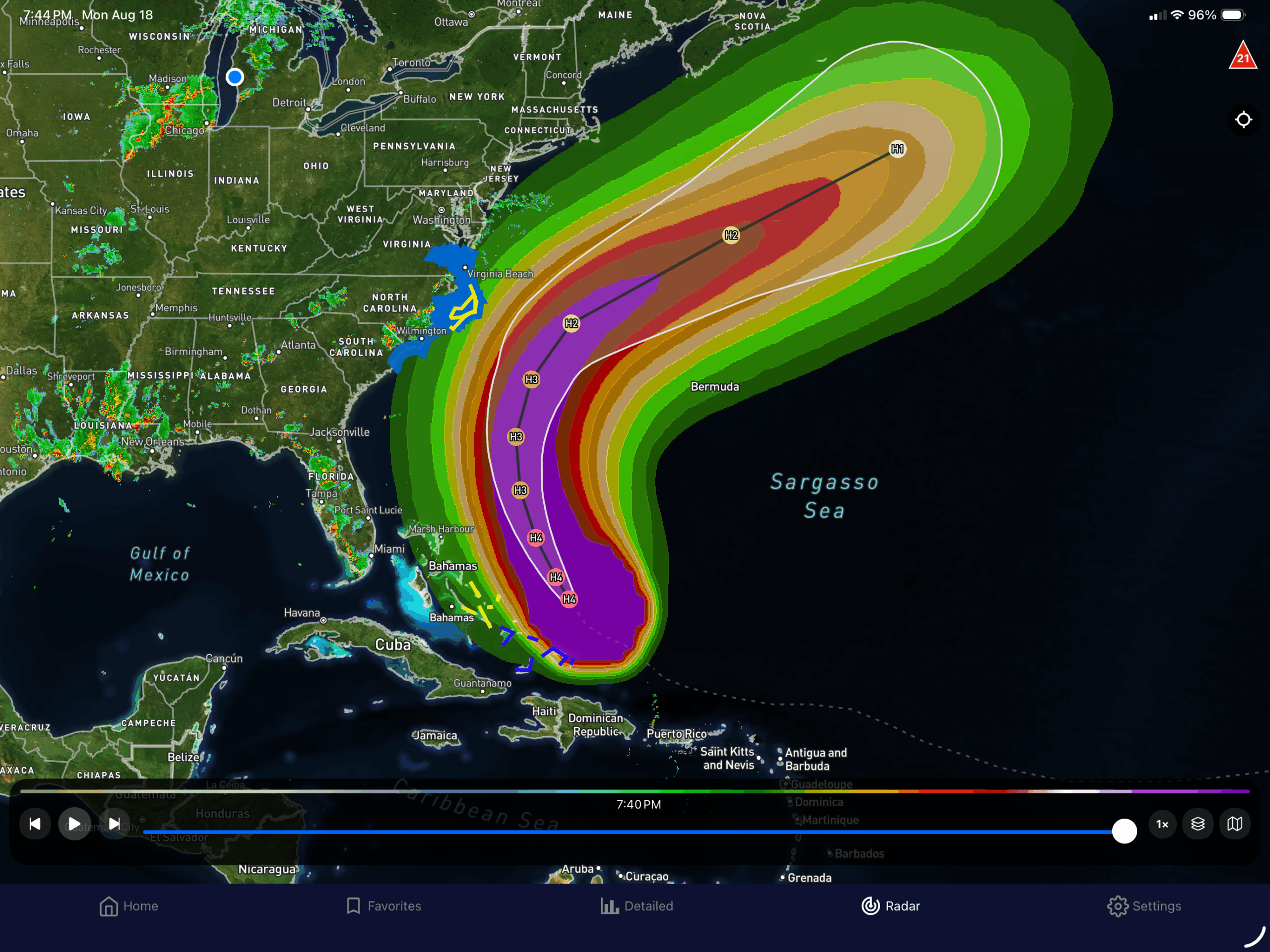

So looking at the graphic on the left is the whole path through the next 5 days with the probability for Tropical force winds (34+ knots). The purple color are 90-100% chance with each color 10% less.
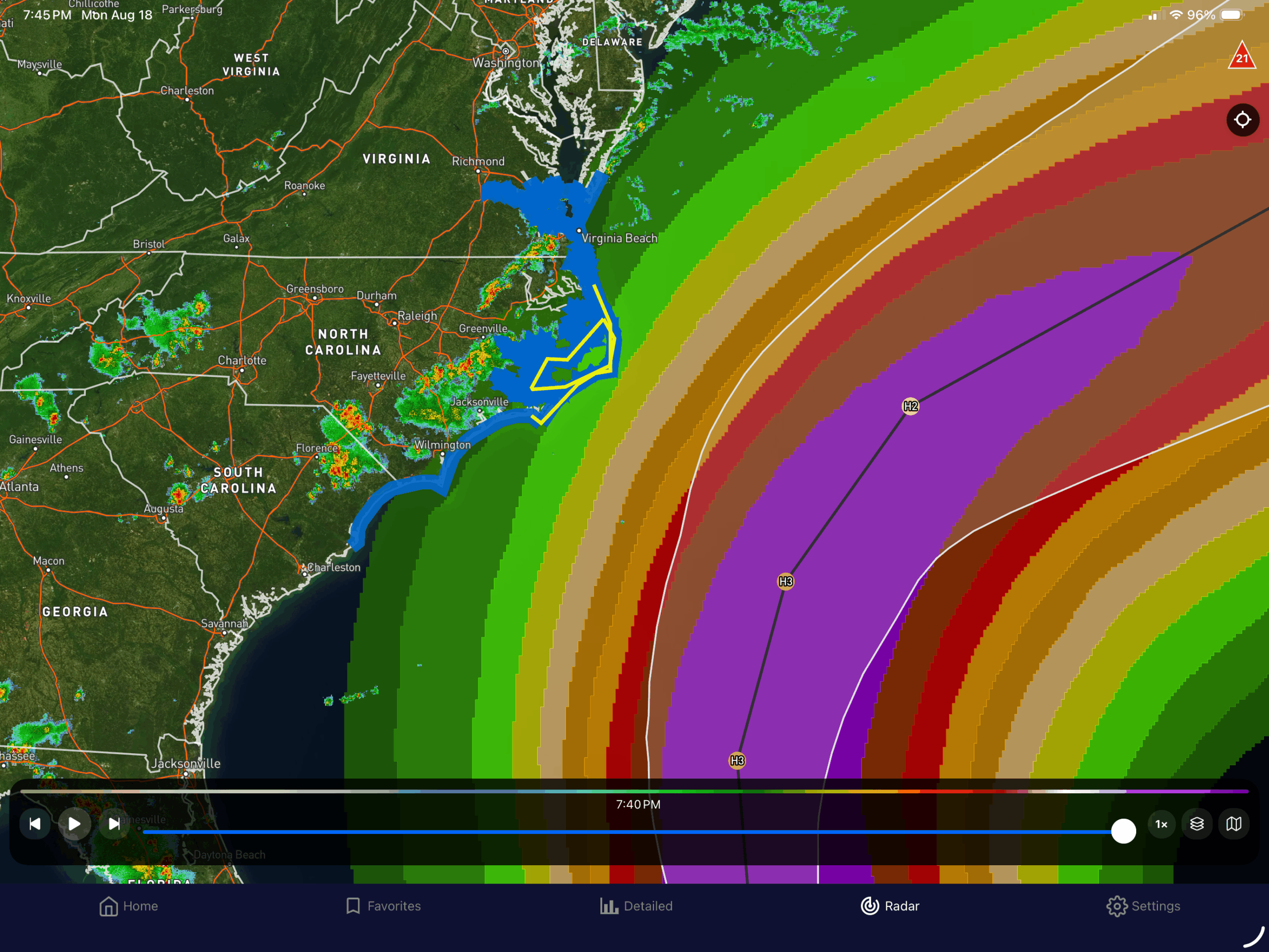
The middle graphic is the current effect on the islands with the Turks and Caicos, and Southeast Bahamas having tropical storm warnings and watches in the central Bahamas. The graphic on the right shows that there are now tropical storm warnings for the Outer Banks and there is a storm surge forecast for 1-3 feet along South Carolina’s Grand Strand and Northern Strand. 2-4 foot surge along the Outer Banks, and 1-3 north of there into Norfolk, VA.
With the wave action (16-30ft offshore), the rip currents are going to be high.
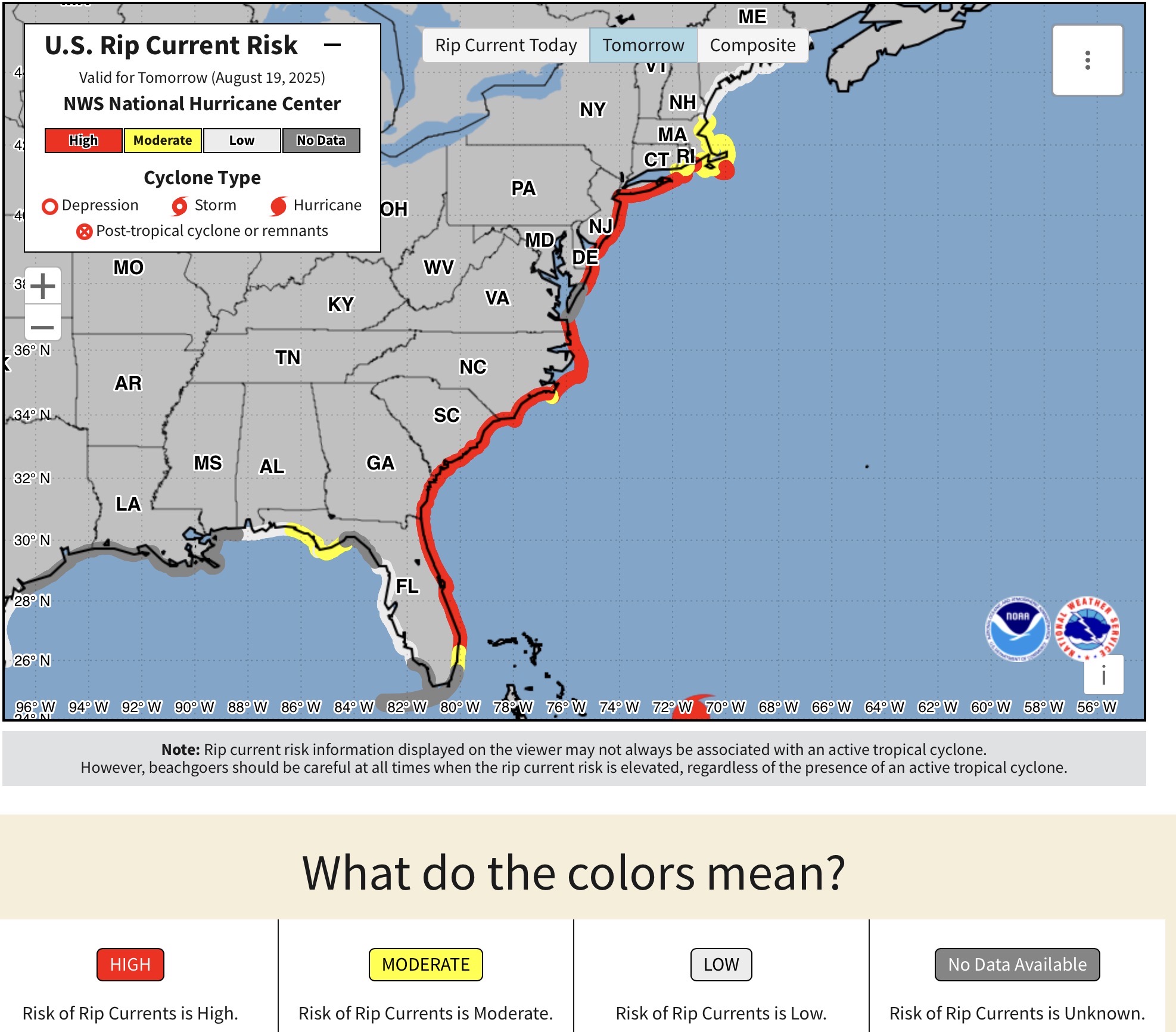
Currently, and mainly tomorrow (which will probably remain for the next few days), There are High Rip Current Risks from around Boca Raton, FL north to Nantucket Island. That means, that even if the weather looks good, the rip currents will begin to form along the coast as the swell periods increase (more wave energy). So stay out of the water. I know with the Waves big, surfs up! Just be careful and stay with your surfboard, and surf with a buddy. But you too, should stay out of the water.
Then there’s this…
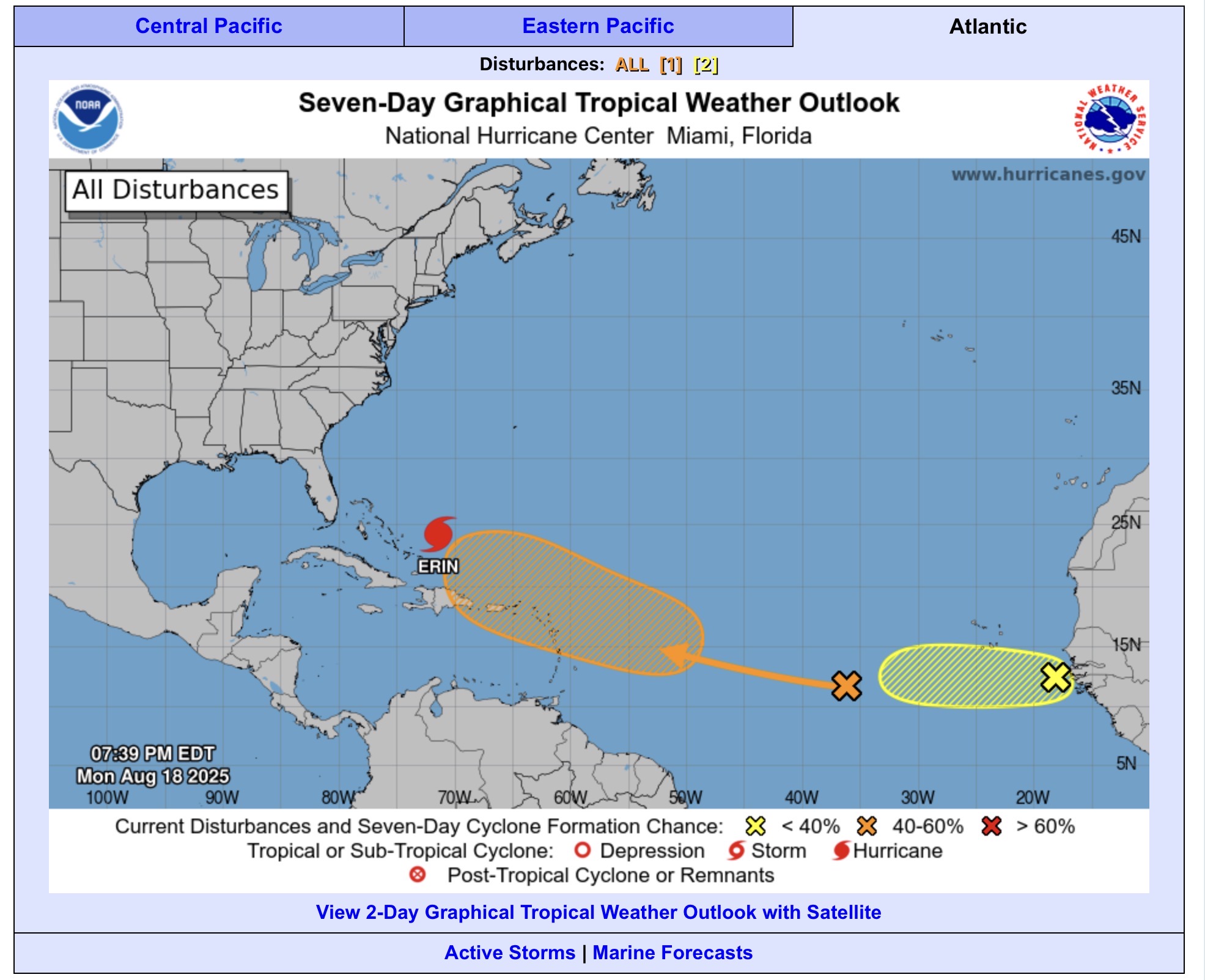
Obviously Erin leads the train, but second is the 60% chance (Orange) for development. We’ve been talking about that for the last few days, as it looks like it will shift north, and follow Erin to a point. The GEFS (GFS Ensemble) shows the member low centers scatter by 180 hours (early morning Aug 26) with some following the same path as Erin, and some move inland into Georgia/Carolinas/Florida. Then on the 7:30 pm there is now a 10% chance development for a wave that has just come off of Africa. This will be interesting over the next 2 weeks.
Looking around Lower Michigan and South Texas, we got a reprieve from the heat and humidity today in Lower Michigan as the front went through. That won’t be the case in a day or two. In South Texas, it is summer, and the movement of 98L’s energy out of the region is showing a sunny and hot Sunday. For both places, the beaches would be nice. Although, Lower Michigan has some issues with rip currents today. So, let’s look at the maps…


Looking at the upper air pattern in the upper left of the gallery, the Upper Great Lakes are in NW flow, but it seems that won’t be for long as the ridge moves east and flattens a bit (Here comes the heat!). South Texas, remains hot and with the ridge over the region.


So no thunder threat today in South Texas, or Lower Michigan (Well, okay south of a line from Benton Harbor to Niles there is general thunder).


Looks like Lower Michigan gets in on the thunder action tomorrow (Monday and Tuesday) with general thunderstorms.
Looks like theGulf moisture increases again and the sea breeze produces some thunder chances Monday. Tuesday has the chance of thunder across the whole state.


Looks like most of Texas misses out on the heavy rain and the chances are less than 5%. However, Lower Michigan has chances of 5-14% for excessive heavy rain leading to flash flooding Monday and Tuesday with the next system.


In the tropics, Erin (currently, a category 3 hurricane) continues to follow (more or less) the path that the models have been saying. The color overlaid with the path is the chance of tropical storm force winds impacting area. The northern part of the island of Hispaniola is only in a 5% chance, but the Turks and Caicos islands are 20-50% chance and have a Tropical Storm Warning, with a few of the southern Bahama islands with a Tropical Storm Watch. The Outer Banks in North Carolina have a 5% chance for Tropical Storm Winds, as Erin moves NE, and Bermuda, on the other side of the Hurricane has a 20% chance (at this time) of Tropical Storm Winds. The main impact, since the storm is currently expected to remain offshore will be High Rip Current Risks and beach flooding.
Okay, so let’s look at local Beach forecasts for Lower Michigan and South Texas…
For lower Michigan…
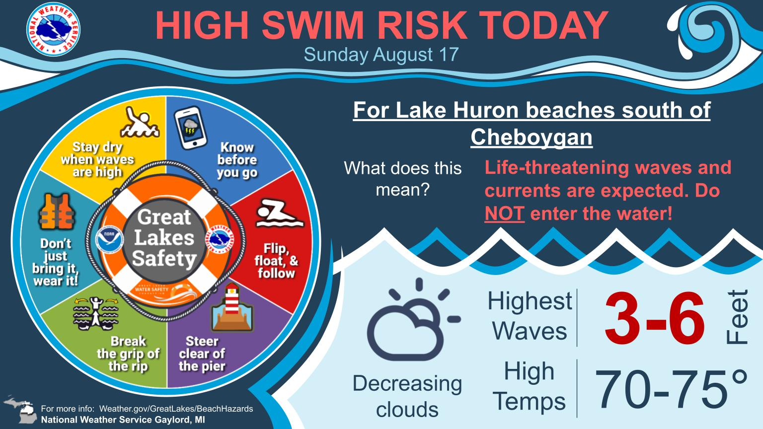


The wind is out of the NNE so and will get going, during the afternoon. So then Lake Huron Beaches are at a high risk, while most of the Lake Michigan beaches are moderate to high. Temperatures are cooler than yesterday, with temperatures in NE Lower around 70° and the SW Lower will be in the mid 80s.


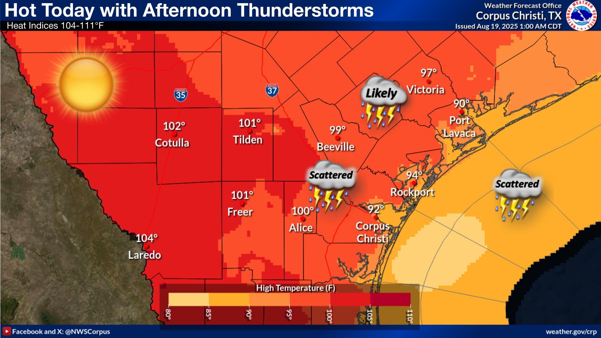
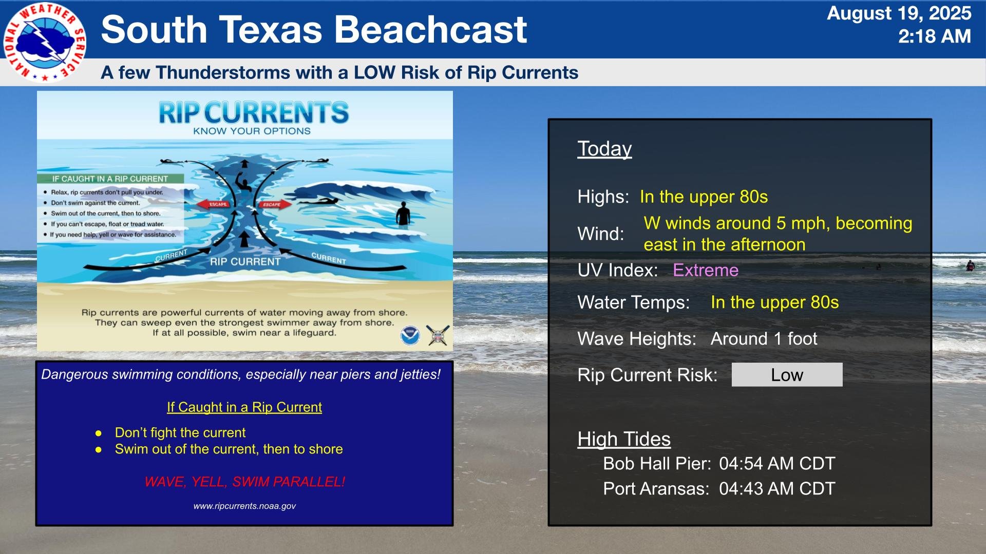
Temperature today will be from the upper 80s at the Beaches to around 100º inland in the Coastal Plains and the Victoria Crossroads. For the Brush Country and the Rio Grande Plains, 100-105º. If you are used to the heat, and hydrate, it should be a good day in the Brush Country. However, if it were me, my wife and I would head to the beaches. Especially, since there is a low rip risk and the 10 MPH onshore wind would keep us cool.
Have a great day!
After yesterday’s hot, sunny weather, here in West Michigan, it looks like things will take a turn today. 98L did bring some rain to the Nueces River basin, but not as much as the models said. There is still a threat for showers and Thunderstorms in South Texas. Here are the details…


That cold front that we talked about yesterday, will move into lower Michigan today, and by late this evening be in southern lower Michigan. This is bringing moderate to high chance that there will be showers and thunderstorms. SPC and WPC has us outlooked for marginal risk (Level 1 out of 5) respectively, but the slight risks (2 of 5) for both is just west in Wisconsin. However, the front fizzles overnight, and Sunday looks to be sunny to partly cloudy. It will still be warm today with mid 80s to the lower 90s in Lower Michigan.


I was talking about the front moving south. Here you can see as it moves into northern lower this afternoon, and southern lower this evening and overnight.

This morning’s analysis doesn’t look too different from other days. Weak onshore flow with a heat low to the west. Well, maybe not a heat low. Take a look at the satellite from the past 18 hours. You see 98L move ashore with its center moving west and the cloud shield trying to move north, into a thunderstorm sheared environment.

South Texas did get some rain in the basin, but not as much that was expected.
So for the details of the forecasts (didn’t I see that before?)…Lower Michigan Beaches have a low risk of rip currents today, but thunderstorms are expected to be scattered to numerous by the afternoon, and lasting into this evening.


For the South Texas beaches, there will be a few showers and thunderstorms, with a high risk of rip currents due to the lingering effects of Invest 98L.


So what ever you do today, have a great day!
We have family coming today, and another busy day of errands. The RV is being washed, due to all of the bugs and road grime on our trip back to Michigan. We do have a few leads on selling it. I like doing the videos, but the editing and uploading takes more time, so another post…
We have another jet streak, moving across the Northern Plains today, with low pressure and a few fronts hanging around the region.
This leads to the front in the upper left of the Great Lakes analysis pushing into the Upper Great Lakes tonight, although showers are already showing up on radar in Wisconsin.

The front and lows lead to the slight risk (2 of5) for severe thunderstorms and Excessive heavy rain in the Upper Mississippi Valley. So in Lower Michigan, Sunny skies, but the thunderstorms will begin to encroach on West Michigan and NW Lower overnight. There is a slight risk from the moisture moving up from Mexico into Arizona and there is a slight risk for heavy rain with Invest 98L which is moving out of the southwestern Gulf, and the Rio Grande Valley, and South Texas. Watch out for this feature the next couple of days, but not for development, but for the possibility of heavy rain going into South Texas.
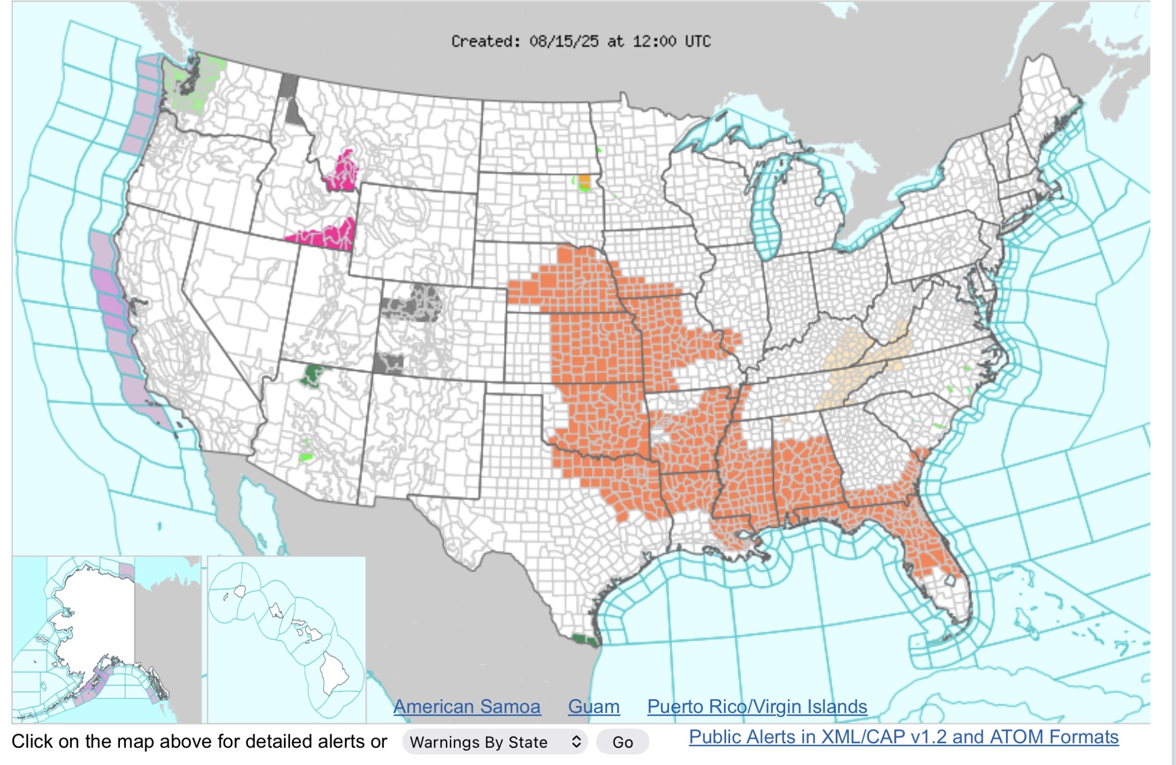
Current WWA is mainly heat related in the Central Plains and into the Gulf Coast States. The Red Flag warnings are less out west as the winds have dropped to 5-10 mph, but it is still very dry in the afternoon. Watch out for Burn bands.
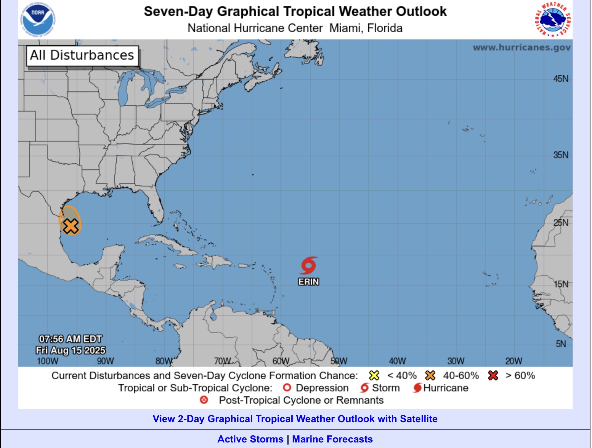
I mentioned 98L earlier, which is that orange X and hatched area. There is a 50% chance it could develop into a tropical depression today, before it make landfall tonight. However, the heavy rain threat is the main issue to watch today through the weekend, depending on how long the moisture and forcing sticks around.
Erin continues to move WNW away from the islands, and current model tracks show the projected path to be between the US Coast, and Bermuda and the passing NE out to sea. If you are in either area (US or Bermuda) keep an eye on it. A little course change could bring issues to either place.
We’ve talked about the local impacts for both Lower Michigan and South Texas today, so the temperatures for both places look like this…
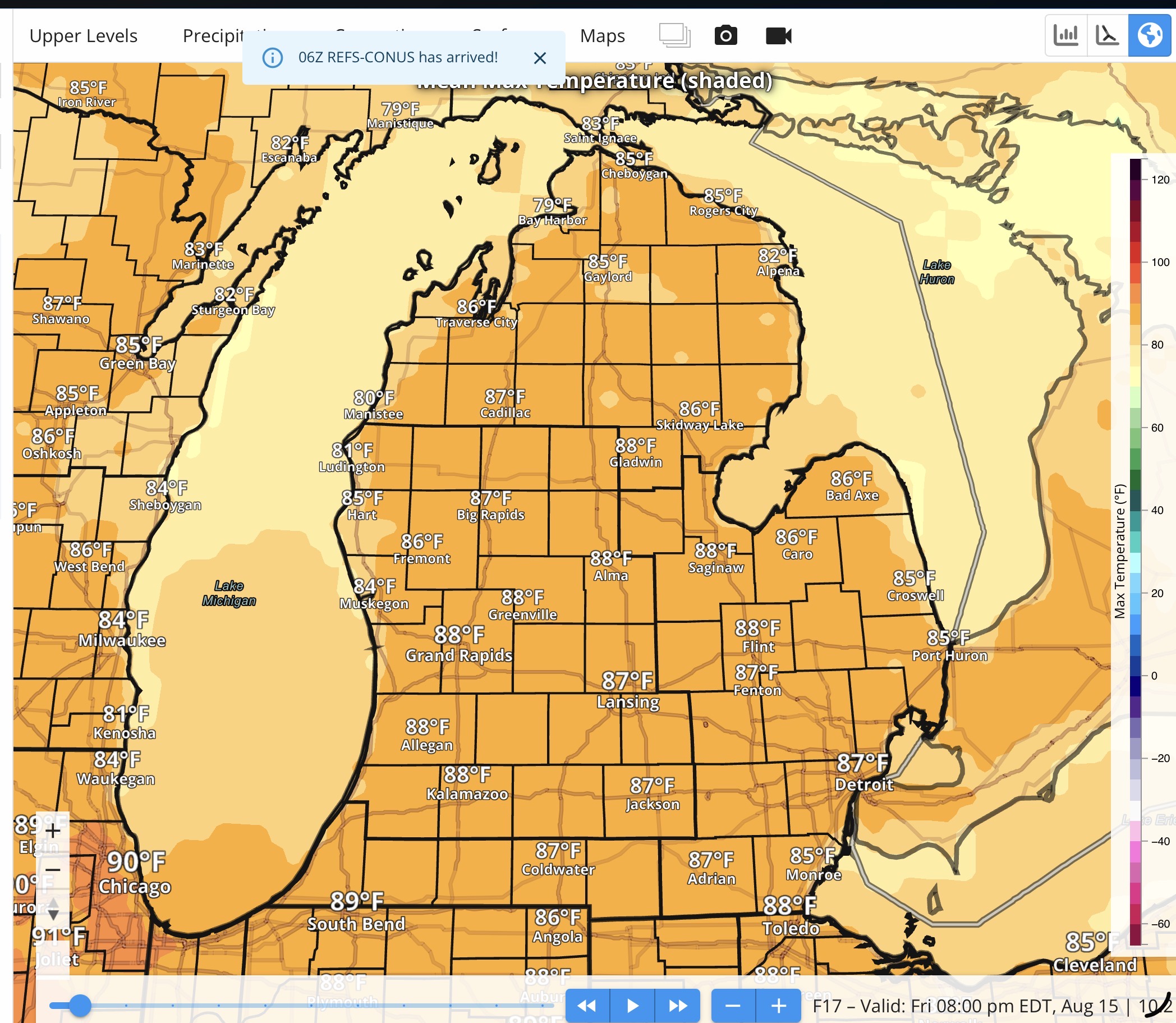
Mid to upper 80s in Lower Michigan today, lower 80 at the beaches.
For South Texas, it’s summer…Upper 80s to around 90 along the Coastal Bend and Coastal Plains (Victoria Crossroads too). Mid 90s to lower 100s (102º in Laredo).
Rip Current Risk along the beaches in Michigan remains low. While the Rip Current Risk along the Middle Texas Coast is expected to moderate today with 98L generating some bigger swell.
Video is here…