
I am a meteorologist and a former youth leader at church…I have a lot to say on both subjects…and then some
It’s been a while. I have pretty much given up on my Northern Michigan Recreational Weather Blog, and started to blog from here again. A lot of that has to do with WordPress.com charging to embed YouTube videos. Since this is a self-funded blog site, under my wife’s business, I started to do my Coffee and a Weather Map series. However, that has had to be put on hold since the summer, when we moved into a 5th wheel. I haven’t done much with it mainly due to bandwidth issues, and, while in Florida, I lost my Apple Pencil. Since we moved into a cottage south of Gaylord, Our bandwidth, hasn’t improved by much, and now we have power constraint issues. However, on a whole, things have been going well.
However, what first started this post was a comment on the office Facebook page that irked me from a storm that went through the region toward the beginning of the month.
The comment was something along the lines of “with all this technology you’d think we would get better forecasts.”
Blah. My emotional response would have been to sarcastically point out how much better forecasting is since when I got into the business over 30 years ago. I remained calm and moved ahead, ignoring the comment.
I remember being in awe as the NGM (Nest Grid Model) picked up that a wave would produce an east coast storm 48 hours in advance of it hitting anything. Now, we can generally see out 6 or 7 days, although not all the time, and see the possibility of something coming.
That extra time we have now, must be messaged properly so that people will know what to do. However, most of the public can only ask how much snow is going to fall in x city, when there are still lots of uncertainties. We try to message things generally when a system is 5 days out. We try to not get into too much detail since the path track of a storm will change and fluctuate, sometimes by 100s of miles, when within the last 12 hours, the track may be off by 25 miles, and producing more or less snow than was predicted for some locations.
Luckily, we have people who like our work and come to our defense siting their snow fall and the prediction. Over the years, I’ve become accustomed to the generally ignorant comments on social media, but every once in a while…
 As the sun is shining over northern Michigan this morning, I pause to remember…
The remembrance is bittersweet, which, for a meteorologist, most are. The storms that gave us awe for the power of nature, also tends to take life. So we balance our excitement of a storm with the recollection that some people die within these storms…
There are about 5 different storms when I was a kid that kept me on track to become a meteorologist:
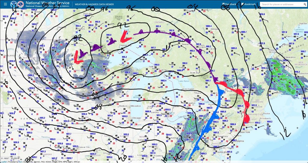
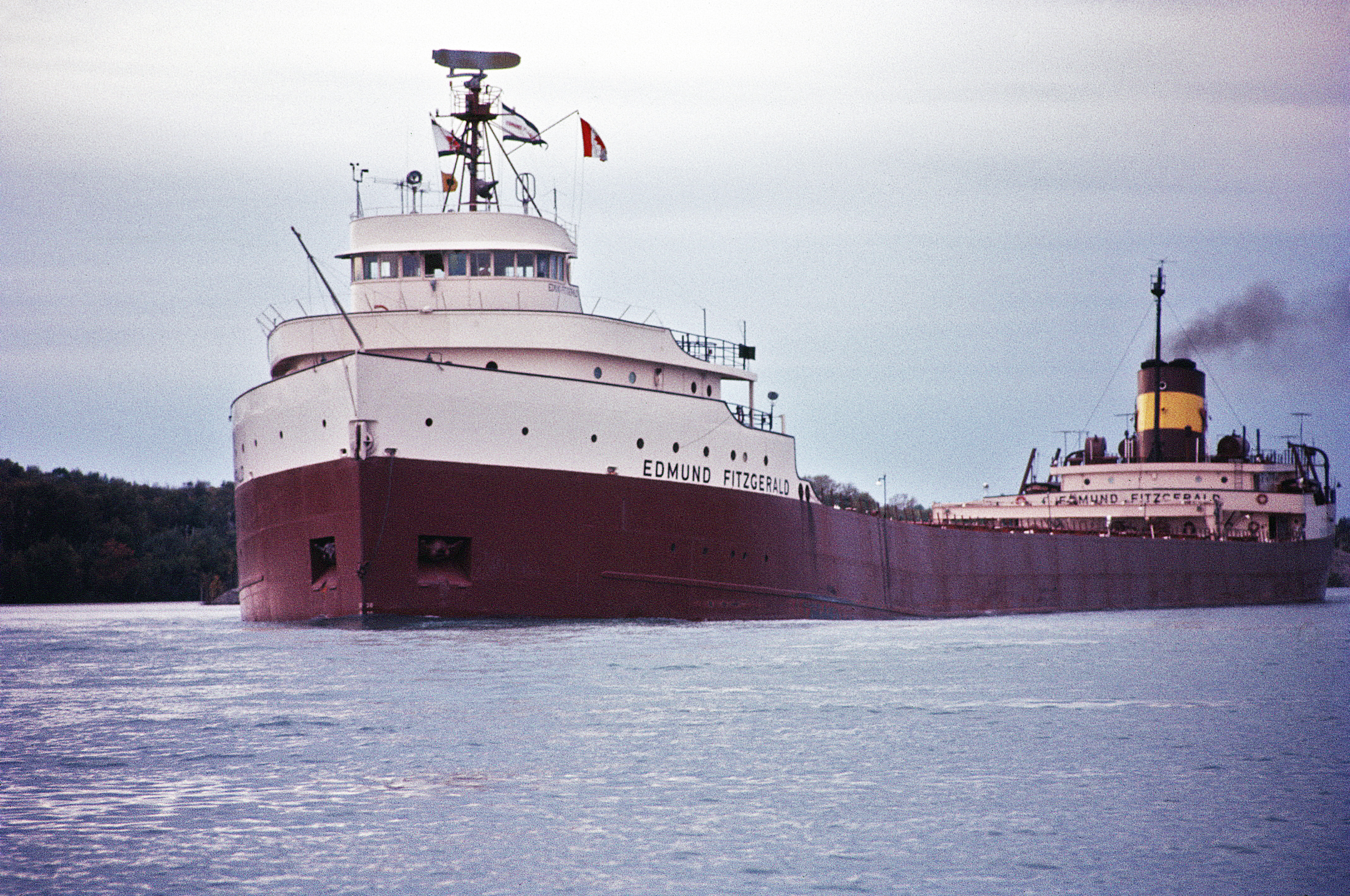
The storm was truly remarkable, with a low pressure of 978mb when the storm’s center moved to just southwest of James Bay, which allowed for the hurricane force northwest winds over Lake Superior and rest of the Upper Great Lakes.
The hurricane gusts reached into southwest lower Michigan. Those gusts stirred up the ashes in our fire place, which had a set of glass doors on them, and left what looked like ghostly imprints of dancers.
Of course, later we would learn via Harry Reasoner and ABC News (probably WZZM out of GRR as well) that the S/S Edmund Fitzgerald was missing and was eventually found in 530 ft of water north of Whitefish Point.
Blogging note** My posterous site is being dumb, so I’m here on my main site for the time being.
…WINTER STORM WARNING IN EFFECT FROM 7 AM THURSDAY TO 7 PM EST FRIDAY…
THE NATIONAL WEATHER SERVICE IN GAYLORD HAS NOW ISSUED A WARNING FOR A DANGEROUS COMBINATION OF HEAVY SNOW AND BLOWING SNOW FROM 7 AM THURSDAY TO 7 PM EST FRIDAY.
 The area in pink, or whatever shade that is, over the land is where the dangerous winter weather is expected. The blue/gray area is where there is a watch or there is a potential for dangerous winter weather.
 I’ve looked through the model runs from last night, which is how HPC got this low track. This looks good. In fact, this a bit further south, which means we are more likely in the colder air so that there will be a minimum of rain mixing in with the snow. Winds don’t look like they will get to Blizzard conditions, but it will be blowing enough late Thursday that it won’t matter in some of the more open areas.
 So for the 12 hours ending at 7pm Thursday (00zFri), here are the snow fall accumulations to be expected. The best snow fall areas will be in the southwest portion of the NWS Gaylord county warning area with the axis of the highest amounts roughly running from Frankfort to Drummond Island. For the 12 hour period (7a-7p), these snow fall totals exceed the warning criteria of 6 inches in 12 hours.
 This is for 7pm Thursday to 7am Friday, with the axis of the best snow still along the line from Frankfort to Drummond Island. While these totals don’t exceed the warning criteria for 12 hours. when added to the previous map, the 24 hour totals exceed the 24 hour warning criteria of 8 inches. Not to mention that the winds overnight will be blowing about 20 to 30 mph.

Of course, let’s not forget our friend, lake effect. It will continue through the weekend. Some areas receive more snow on top of the storm system snow through the weekend. Too early to tell the amounts. However, Friday and Friday night could continue to be significant, as the mid level moisture will be there. Saturday and Sunday, depending on how much moisture is there will determine whether we get light to moderate amounts, or moderate to heavy. Stay tuned.
I will be Going to GRR and back on Thursday…I’ll try to get some pictures and do some on the fly blogging if I can.


No sooner did September start that our first cold air outbreak occur and we are getting lake effect rain showers. Droplets were a little hard to see in the picture, but the somewhat lowered visibility can be seen with the break in the clouds.
 Here’s the radar from the afternoon with the rain band off the lake.
Of course, with those words, that’s when the sky splits open and it pours. However, if you look at this picture:
 Then you see that the main rain has again gone by to the north and the south. This is also the case of Boyne Falls, where I am typing this morning. I know many will say, “But Jeff, look at that mass of rain to the west of you. Surely that will bring some relief?” Well as I have been watching it on the radar the heavier rain has been heading south and the weaker area is beginning to open up.
To see how we got into our drought, watch this video below put together by Nick Schwartz (aka Shaggy), a meteorological intern at our office.

I can still get come geeking in before work.
While this product is formatted for the Wildland Fire Community, it has a good writeup for what's going on. The Hazardous Weather Briefing should be out now.
FIRE WEATHER PLANNING FORECAST FOR NORTHERN LOWER MICHIGAN NATIONAL WEATHER SERVICE GAYLORD MI 404 PM EDT MON JUN 6 2011 ...INCREASING HEAT AND HUMIDITY WITH CHANCES OF THUNDERSTORMS THROUGH WEDNESDAY... .DISCUSSION...A WARM FRONT WILL SLOWLY LIFT NORTH INTO NORTHERN MICHIGAN TONIGHT. THIS FRONT WILL USHER IN INCREASING HEAT AND HUMIDITY THROUGH MIDWEEK...AS WELL AS PROVIDE SEVERAL CHANCES FOR SHOWERS AND THUNDERSTORMS TUESDAY AND WEDNESDAY. WINDS WILL REMAIN LIGHT OUT OF THE SOUTH DURING TUESDAY MORNING...THEN WILL SHIFT TO THE SOUTHWEST IN THE AFTERNOON. LOCALIZED LAKE BREEZES WILL ALSO BE POSSIBLE TUESDAY AFTERNOON AS WELL. SOUTHWEST WINDS ARE EXPECTED TO BE MORE BREEZY ON WEDNESDAY AHEAD OF AN APPROACHING COLD FRONT. THE THREAT FOR PRECIPITATION WILL END ON THURSDAY AS THE COLD FRONT SWEEPS THROUGH THE REGION...USHERING IN COOLER AND DRIER WEATHER BY THE END OF THE WORK WEEK.

From the Storm prediction Center:
AREAS AFFECTED...UPPER PENINSULA OF MI/NERN WI CONCERNING...SEVERE POTENTIAL...WATCH POSSIBLEVALID 061902Z - 062100Z STORMS MAY DEVELOP OVER THE NEXT HOUR ACROSS WRN UPPER MI AND ADJACENT NRN WI...WITH SOME POTENTIAL FOR DAMAGING WINDS AND/OR HAIL EVIDENT. WW MAY BE REQUIRED.
So we may be under a wach in NW Lower Michigan coming up with the next hour for a good portion of the night. Mary is in town, so if the office did call me to work the event, I couldn’t with no transport. So, it looks like I will be liveblogging anything that happens this evening.

Here’s the discussion from SPC this afternoon:
...UPR MS VLY/WRN GRT LKS THIS AFTN THROUGH TNGT...
CONSIDERABLE CLOUD COVER REMAINING FROM OVERNIGHT CONVECTION WILL CONTINUE TO THIN ACROSS ERN MN/NRN WI INTO THE AFTERNOON ALLOWING STRONG HEATING/DESTABILIZATION TO OCCUR AHEAD OF THE COLD FRONT ACROSS THE EXPANDING WARM SECTOR. THE COMBINATION OF STEEP MID LEVEL LAPSE RATES AND DEWPOINTS RISING TO AROUND 70F WILL LEAD TO MDT/STG INSTABILITY BY MID AFTERNOON WITH MLCAPES TO AOA 3000 J/KG. WITH THE PRONOUNCED EML ACROSS THE AREA...TIMING OF SURFACE INITIATION OF SEVERE THUNDERSTORMS IS A CONCERN AND APPEARS SHOULD BE DELAYED TO MID OR LATE AFTERNOON. LACK OF ANY SUBSTANTIAL UPPER FORCING WITH THE SWLY FLOW WILL LIKELY REQUIRE FULL HEATING TO OVERCOME THE CAPPING NOW IN PLACE. ONCE STORMS FORM...40-50 KT DEEP WSWLY SHEAR AND STEEP MID LVL LAPSE RATES SHOULD SUPPORT SUPERCELLS/SUSTAINED STORMS WITH LARGE HAIL...DMGG WIND...AND POSSIBLY TORNADOES. THE LATTER THREAT SHOULD BE GREATEST IN NRN WI...WHERE LOW LVL SRH SHOULD BE MAXIMIZED IN ZONE OF LOW LCLS NEAR THE WARM FRONT. BY EARLY TONIGHT...EXPECT STORMS TO MERGE INTO ONE OR MCS/S. WIND PROFILES AND THERMODYNAMIC ENVIRONMENT APPEAR FAVORABLE FOR BOWING SEGMENTS WITH AN INCREASING THREAT DMGG WIND IN WI AND POSSIBLY NRN MI.
As you can read there is a chance for stuff to form in northern Minnesota and Wisconsin, where there are two tornado watches currently. Then as the storms merge, a large complex of thunderstorms with high winds could form and move into Upper and Northern Lower Michigan. The News story from NWS Gaylord has when we are expecting the worst stuff and what it will be: Some thunderstorms tonight will have the potential to be severe, mainly between 10 pm and 6 am. The main severe weather threats will be:
So far, the there are thunderstorms are forming, but no complex as of yet.
